You are here: Home > Network List > GO - National Seismic Network of Georgia Stations List
> Station EMLK Emlikli, Georgia > Earthquake Result Viewer
EMLK Emlikli, Georgia - Earthquake Result Viewer
| Earthquake location: |
Southeast Of Ryukyu Islands |
| Earthquake latitude/longitude: |
29.5/131.7 |
| Earthquake time(UTC): |
2024/04/15 (106) 22:38:57 GMT |
| Earthquake Depth: |
8.0 km |
| Earthquake Magnitude: |
5.9 mww |
| Earthquake Catalog/Contributor: |
NEIC PDE/us |
|
| Network: |
GO National Seismic Network of Georgia |
| Station: |
EMLK Emlikli, Georgia |
| Lat/Lon: |
41.21 N/43.95 E |
| Elevation: |
2939 m |
|
| Distance: |
69.7 deg |
| Az: |
306.511 deg |
| Baz: |
68.277 deg |
| Ray Param: |
0.05546914 |
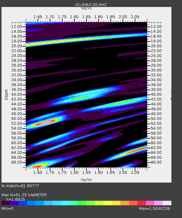
| Estimated Moho Depth: |
51.25 km |
| Estimated Crust Vp/Vs: |
1.68 |
| Assumed Crust Vp: |
6.419 km/s |
| Estimated Crust Vs: |
3.815 km/s |
| Estimated Crust Poisson's Ratio: |
0.23 |
|
| Radial Match: |
81.98777 % |
| Radial Bump: |
400 |
| Transverse Match: |
74.42346 % |
| Transverse Bump: |
400 |
| SOD ConfigId: |
34194791 |
| Insert Time: |
2024-04-29 22:57:30.058 +0000 |
| GWidth: |
2.5 |
| Max Bumps: |
400 |
| Tol: |
0.001 |
|

Signal To Noise
| Channel | StoN | STA | LTA |
| GO:EMLK:00:HHZ:20240415T22:49:36.089972Z | 7.586208 | 5.1489604E-7 | 6.7872655E-8 |
| GO:EMLK:00:HHN:20240415T22:49:36.089972Z | 1.8196775 | 1.9599966E-7 | 1.0771121E-7 |
| GO:EMLK:00:HHE:20240415T22:49:36.089972Z | 0.94241536 | 1.807458E-7 | 1.9178995E-7 |
| Arrivals |
| Ps | 5.7 SECOND |
| PpPs | 21 SECOND |
| PsPs/PpSs | 26 SECOND |


