You are here: Home > Network List > IO - International OGS Network Stations List
> Station EVN EvK2CNR Pyramid Laboratory - Mount Everest > Earthquake Result Viewer
EVN EvK2CNR Pyramid Laboratory - Mount Everest - Earthquake Result Viewer
| Earthquake location: |
Southeast Of Ryukyu Islands |
| Earthquake latitude/longitude: |
29.5/131.7 |
| Earthquake time(UTC): |
2024/04/15 (106) 22:38:57 GMT |
| Earthquake Depth: |
8.0 km |
| Earthquake Magnitude: |
5.9 mww |
| Earthquake Catalog/Contributor: |
NEIC PDE/us |
|
| Network: |
IO International OGS Network |
| Station: |
EVN EvK2CNR Pyramid Laboratory - Mount Everest |
| Lat/Lon: |
27.96 N/86.81 E |
| Elevation: |
5010 m |
|
| Distance: |
39.2 deg |
| Az: |
279.106 deg |
| Baz: |
76.747 deg |
| Ray Param: |
0.07511912 |
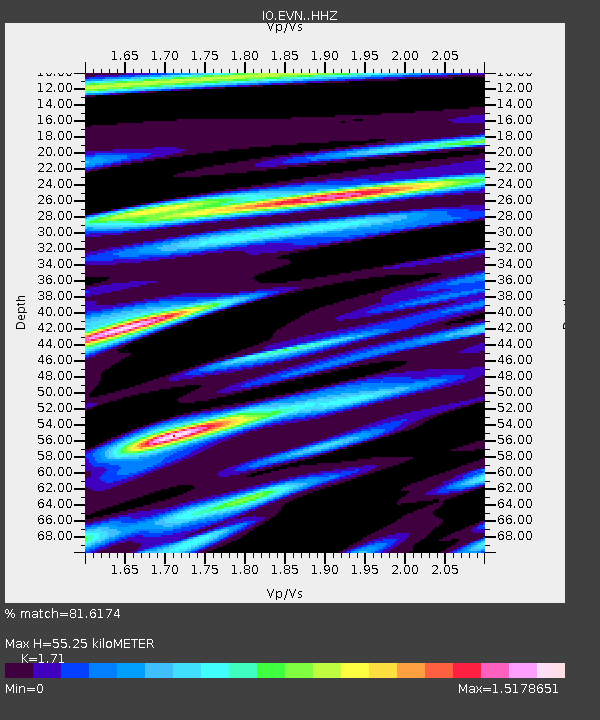
| Estimated Moho Depth: |
55.25 km |
| Estimated Crust Vp/Vs: |
1.71 |
| Assumed Crust Vp: |
6.236 km/s |
| Estimated Crust Vs: |
3.647 km/s |
| Estimated Crust Poisson's Ratio: |
0.24 |
|
| Radial Match: |
81.6174 % |
| Radial Bump: |
362 |
| Transverse Match: |
68.841576 % |
| Transverse Bump: |
400 |
| SOD ConfigId: |
34194791 |
| Insert Time: |
2024-04-29 22:59:24.349 +0000 |
| GWidth: |
2.5 |
| Max Bumps: |
400 |
| Tol: |
0.001 |
|

Signal To Noise
| Channel | StoN | STA | LTA |
| IO:EVN: :HHZ:20240415T22:45:55.079992Z | 9.39528 | 6.018571E-7 | 6.405952E-8 |
| IO:EVN: :HHN:20240415T22:45:55.079992Z | 3.7406228 | 1.08916154E-7 | 2.9117118E-8 |
| IO:EVN: :HHE:20240415T22:45:55.079992Z | 11.381698 | 3.5953101E-7 | 3.158852E-8 |
| Arrivals |
| Ps | 6.7 SECOND |
| PpPs | 22 SECOND |
| PsPs/PpSs | 29 SECOND |


