You are here: Home > Network List > TA - USArray Transportable Network (new EarthScope stations) Stations List
> Station T26A Comanche National Grassland Park, Kim, CO, USA > Earthquake Result Viewer
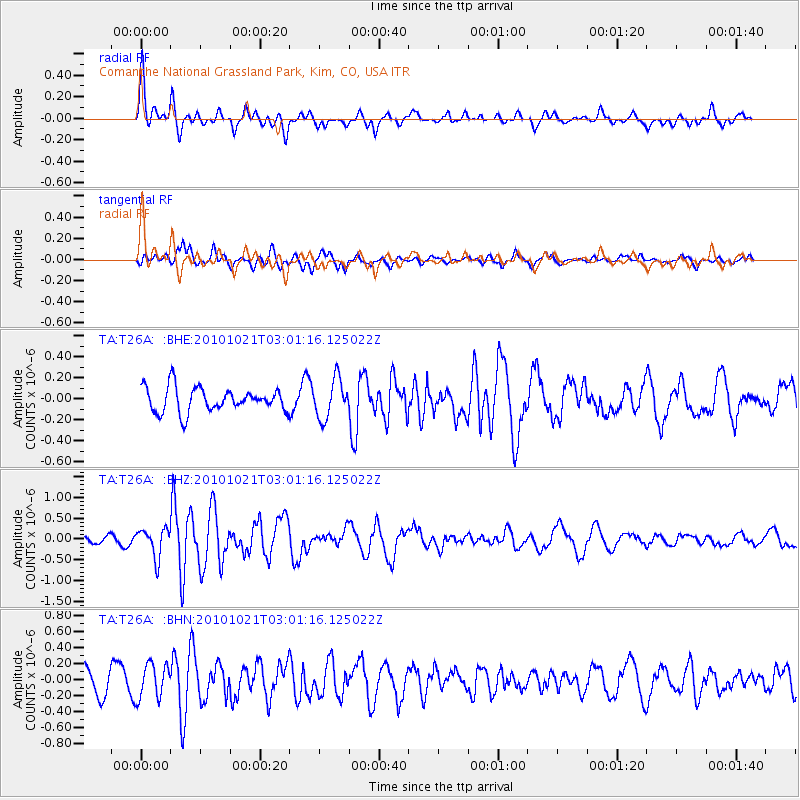
T26A Comanche National Grassland Park, Kim, CO, USA - Earthquake Result Viewer
*The percent match for this event was below the threshold and hence no stack was calculated.
| Earthquake location: |
Off Coast Of Central Chile |
| Earthquake latitude/longitude: |
-34.7/-73.7 |
| Earthquake time(UTC): |
2010/10/21 (294) 02:49:56 GMT |
| Earthquake Depth: |
10 km |
| Earthquake Magnitude: |
5.9 MB, 5.5 MS, 5.9 MW, 5.8 MW |
| Earthquake Catalog/Contributor: |
WHDF/NEIC |
|
| Network: |
TA USArray Transportable Network (new EarthScope stations) |
| Station: |
T26A Comanche National Grassland Park, Kim, CO, USA |
| Lat/Lon: |
37.17 N/103.59 W |
| Elevation: |
1830 m |
|
| Distance: |
76.8 deg |
| Az: |
335.877 deg |
| Baz: |
155.077 deg |
| Ray Param: |
$rayparam |
*The percent match for this event was below the threshold and hence was not used in the summary stack. |
|
| Radial Match: |
73.045906 % |
| Radial Bump: |
400 |
| Transverse Match: |
58.513424 % |
| Transverse Bump: |
346 |
| SOD ConfigId: |
339645 |
| Insert Time: |
2011-02-17 09:15:06.528 +0000 |
| GWidth: |
2.5 |
| Max Bumps: |
400 |
| Tol: |
0.001 |
|
Signal To Noise
| Channel | StoN | STA | LTA |
| TA:T26A: :BHZ:20101021T03:01:16.125022Z | 4.428921 | 3.4384715E-7 | 7.763677E-8 |
| TA:T26A: :BHN:20101021T03:01:16.125022Z | 1.7447144 | 2.1165118E-7 | 1.2130992E-7 |
| TA:T26A: :BHE:20101021T03:01:16.125022Z | 1.6087843 | 1.8575348E-7 | 1.15462015E-7 |
| Arrivals |
| Ps | |
| PpPs | |
| PsPs/PpSs | |


