You are here: Home > Network List > TA - USArray Transportable Network (new EarthScope stations) Stations List
> Station R28A Tribune, KS, USA > Earthquake Result Viewer
R28A Tribune, KS, USA - Earthquake Result Viewer
| Earthquake location: |
Off Coast Of Central Chile |
| Earthquake latitude/longitude: |
-34.7/-73.7 |
| Earthquake time(UTC): |
2010/10/21 (294) 02:49:56 GMT |
| Earthquake Depth: |
10 km |
| Earthquake Magnitude: |
5.9 MB, 5.5 MS, 5.9 MW, 5.8 MW |
| Earthquake Catalog/Contributor: |
WHDF/NEIC |
|
| Network: |
TA USArray Transportable Network (new EarthScope stations) |
| Station: |
R28A Tribune, KS, USA |
| Lat/Lon: |
38.34 N/101.81 W |
| Elevation: |
1108 m |
|
| Distance: |
77.2 deg |
| Az: |
337.689 deg |
| Baz: |
156.572 deg |
| Ray Param: |
0.05045694 |
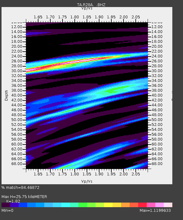
| Estimated Moho Depth: |
25.75 km |
| Estimated Crust Vp/Vs: |
1.82 |
| Assumed Crust Vp: |
6.483 km/s |
| Estimated Crust Vs: |
3.562 km/s |
| Estimated Crust Poisson's Ratio: |
0.28 |
|
| Radial Match: |
84.46872 % |
| Radial Bump: |
322 |
| Transverse Match: |
65.03216 % |
| Transverse Bump: |
377 |
| SOD ConfigId: |
339645 |
| Insert Time: |
2011-02-17 09:19:17.297 +0000 |
| GWidth: |
2.5 |
| Max Bumps: |
400 |
| Tol: |
0.001 |
|

Signal To Noise
| Channel | StoN | STA | LTA |
| TA:R28A: :BHZ:20101021T03:01:18.824973Z | 7.836477 | 7.1905964E-7 | 9.175803E-8 |
| TA:R28A: :BHN:20101021T03:01:18.824973Z | 4.1827335 | 4.0792443E-7 | 9.75258E-8 |
| TA:R28A: :BHE:20101021T03:01:18.824973Z | 1.5504833 | 2.936354E-7 | 1.8938313E-7 |
| Arrivals |
| Ps | 3.4 SECOND |
| PpPs | 11 SECOND |
| PsPs/PpSs | 14 SECOND |


