You are here: Home > Network List > TA - USArray Transportable Network (new EarthScope stations) Stations List
> Station R29A Marienthal, KS, USA > Earthquake Result Viewer
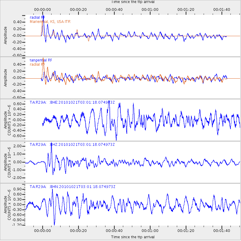
R29A Marienthal, KS, USA - Earthquake Result Viewer
*The percent match for this event was below the threshold and hence no stack was calculated.
| Earthquake location: |
Off Coast Of Central Chile |
| Earthquake latitude/longitude: |
-34.7/-73.7 |
| Earthquake time(UTC): |
2010/10/21 (294) 02:49:56 GMT |
| Earthquake Depth: |
10 km |
| Earthquake Magnitude: |
5.9 MB, 5.5 MS, 5.9 MW, 5.8 MW |
| Earthquake Catalog/Contributor: |
WHDF/NEIC |
|
| Network: |
TA USArray Transportable Network (new EarthScope stations) |
| Station: |
R29A Marienthal, KS, USA |
| Lat/Lon: |
38.42 N/101.14 W |
| Elevation: |
957 m |
|
| Distance: |
77.1 deg |
| Az: |
338.221 deg |
| Baz: |
157.106 deg |
| Ray Param: |
$rayparam |
*The percent match for this event was below the threshold and hence was not used in the summary stack. |
|
| Radial Match: |
59.700565 % |
| Radial Bump: |
400 |
| Transverse Match: |
51.48961 % |
| Transverse Bump: |
388 |
| SOD ConfigId: |
339645 |
| Insert Time: |
2011-02-17 09:19:43.650 +0000 |
| GWidth: |
2.5 |
| Max Bumps: |
400 |
| Tol: |
0.001 |
|
Signal To Noise
| Channel | StoN | STA | LTA |
| TA:R29A: :BHZ:20101021T03:01:18.074973Z | 9.101846 | 6.518849E-7 | 7.162117E-8 |
| TA:R29A: :BHN:20101021T03:01:18.074973Z | 1.5328543 | 3.1243016E-7 | 2.0382247E-7 |
| TA:R29A: :BHE:20101021T03:01:18.074973Z | 1.9422213 | 2.9298423E-7 | 1.5085008E-7 |
| Arrivals |
| Ps | |
| PpPs | |
| PsPs/PpSs | |


