You are here: Home > Network List > TA - USArray Transportable Network (new EarthScope stations) Stations List
> Station J01E Myrtle Point, OR, USA > Earthquake Result Viewer
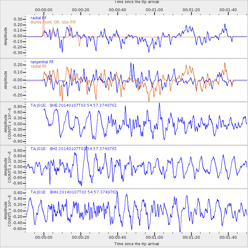
J01E Myrtle Point, OR, USA - Earthquake Result Viewer
*The percent match for this event was below the threshold and hence no stack was calculated.
| Earthquake location: |
Northern Chile |
| Earthquake latitude/longitude: |
-21.0/-69.7 |
| Earthquake time(UTC): |
2014/01/07 (007) 03:43:23 GMT |
| Earthquake Depth: |
87 km |
| Earthquake Magnitude: |
5.4 MW |
| Earthquake Catalog/Contributor: |
ISC/ISC |
|
| Network: |
TA USArray Transportable Network (new EarthScope stations) |
| Station: |
J01E Myrtle Point, OR, USA |
| Lat/Lon: |
43.16 N/123.93 W |
| Elevation: |
128 m |
|
| Distance: |
81.0 deg |
| Az: |
323.06 deg |
| Baz: |
129.881 deg |
| Ray Param: |
$rayparam |
*The percent match for this event was below the threshold and hence was not used in the summary stack. |
|
| Radial Match: |
46.623863 % |
| Radial Bump: |
400 |
| Transverse Match: |
58.972473 % |
| Transverse Bump: |
400 |
| SOD ConfigId: |
3390531 |
| Insert Time: |
2019-04-09 22:03:02.327 +0000 |
| GWidth: |
2.5 |
| Max Bumps: |
400 |
| Tol: |
0.001 |
|
Signal To Noise
| Channel | StoN | STA | LTA |
| TA:J01E: :BHZ:20140107T03:54:57.374976Z | 1.3445158 | 2.9678355E-7 | 2.2073638E-7 |
| TA:J01E: :BHN:20140107T03:54:57.374976Z | 0.75216454 | 1.9492823E-7 | 2.5915637E-7 |
| TA:J01E: :BHE:20140107T03:54:57.374976Z | 1.1578289 | 4.6234624E-7 | 3.9932172E-7 |
| Arrivals |
| Ps | |
| PpPs | |
| PsPs/PpSs | |


