You are here: Home > Network List > TA - USArray Transportable Network (new EarthScope stations) Stations List
> Station I28A Midland, SD, USA > Earthquake Result Viewer
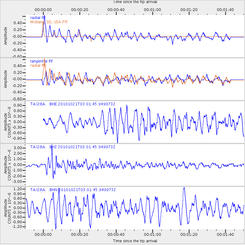
I28A Midland, SD, USA - Earthquake Result Viewer
*The percent match for this event was below the threshold and hence no stack was calculated.
| Earthquake location: |
Off Coast Of Central Chile |
| Earthquake latitude/longitude: |
-34.7/-73.7 |
| Earthquake time(UTC): |
2010/10/21 (294) 02:49:56 GMT |
| Earthquake Depth: |
10 km |
| Earthquake Magnitude: |
5.9 MB, 5.5 MS, 5.9 MW, 5.8 MW |
| Earthquake Catalog/Contributor: |
WHDF/NEIC |
|
| Network: |
TA USArray Transportable Network (new EarthScope stations) |
| Station: |
I28A Midland, SD, USA |
| Lat/Lon: |
44.00 N/101.17 W |
| Elevation: |
655 m |
|
| Distance: |
82.3 deg |
| Az: |
340.384 deg |
| Baz: |
157.473 deg |
| Ray Param: |
$rayparam |
*The percent match for this event was below the threshold and hence was not used in the summary stack. |
|
| Radial Match: |
66.94138 % |
| Radial Bump: |
346 |
| Transverse Match: |
73.9298 % |
| Transverse Bump: |
396 |
| SOD ConfigId: |
339645 |
| Insert Time: |
2011-02-17 09:21:46.459 +0000 |
| GWidth: |
2.5 |
| Max Bumps: |
400 |
| Tol: |
0.001 |
|
Signal To Noise
| Channel | StoN | STA | LTA |
| TA:I28A: :BHZ:20101021T03:01:45.949973Z | 7.603601 | 1.0701717E-6 | 1.4074539E-7 |
| TA:I28A: :BHN:20101021T03:01:45.949973Z | 1.7178377 | 4.839004E-7 | 2.8169157E-7 |
| TA:I28A: :BHE:20101021T03:01:45.949973Z | 1.7934248 | 3.839988E-7 | 2.141148E-7 |
| Arrivals |
| Ps | |
| PpPs | |
| PsPs/PpSs | |


