You are here: Home > Network List > CN - Canadian National Seismograph Network Stations List
> Station DLBC Dease Lake, BC, CA > Earthquake Result Viewer
DLBC Dease Lake, BC, CA - Earthquake Result Viewer
| Earthquake location: |
Tonga Islands Region |
| Earthquake latitude/longitude: |
-19.3/-172.1 |
| Earthquake time(UTC): |
2022/11/11 (315) 10:48:45 GMT |
| Earthquake Depth: |
25 km |
| Earthquake Magnitude: |
7.3 Mww |
| Earthquake Catalog/Contributor: |
NEIC PDE/us |
|
| Network: |
CN Canadian National Seismograph Network |
| Station: |
DLBC Dease Lake, BC, CA |
| Lat/Lon: |
58.44 N/130.03 W |
| Elevation: |
978 m |
|
| Distance: |
84.9 deg |
| Az: |
20.723 deg |
| Baz: |
219.445 deg |
| Ray Param: |
0.045135457 |
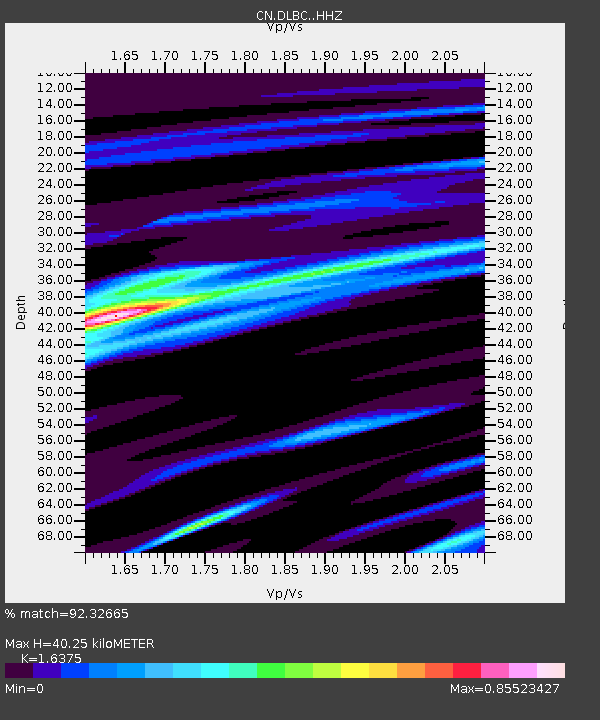
| Estimated Moho Depth: |
40.25 km |
| Estimated Crust Vp/Vs: |
1.64 |
| Assumed Crust Vp: |
6.597 km/s |
| Estimated Crust Vs: |
4.029 km/s |
| Estimated Crust Poisson's Ratio: |
0.20 |
|
| Radial Match: |
92.32665 % |
| Radial Bump: |
296 |
| Transverse Match: |
86.626526 % |
| Transverse Bump: |
400 |
| SOD ConfigId: |
34243671 |
| Insert Time: |
2024-05-01 17:31:35.355 +0000 |
| GWidth: |
2.5 |
| Max Bumps: |
400 |
| Tol: |
0.001 |
|

Signal To Noise
| Channel | StoN | STA | LTA |
| CN:DLBC: :HHZ:20221111T11:00:46.539988Z | 13.200944 | 6.241056E-6 | 4.7277345E-7 |
| CN:DLBC: :HHN:20221111T11:00:46.539988Z | 3.000063 | 1.6883638E-6 | 5.6277617E-7 |
| CN:DLBC: :HHE:20221111T11:00:46.539988Z | 1.3062224 | 1.0729974E-6 | 8.214507E-7 |
| Arrivals |
| Ps | 4.0 SECOND |
| PpPs | 16 SECOND |
| PsPs/PpSs | 20 SECOND |


