You are here: Home > Network List > TX - Texas Seismological Network Stations List
> Station FW07 Weatherford > Earthquake Result Viewer
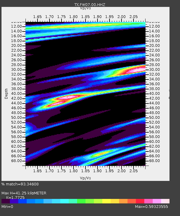
FW07 Weatherford - Earthquake Result Viewer
| Earthquake location: |
Tonga Islands Region |
| Earthquake latitude/longitude: |
-19.3/-172.1 |
| Earthquake time(UTC): |
2022/11/11 (315) 10:48:45 GMT |
| Earthquake Depth: |
25 km |
| Earthquake Magnitude: |
7.3 Mww |
| Earthquake Catalog/Contributor: |
NEIC PDE/us |
|
| Network: |
TX Texas Seismological Network |
| Station: |
FW07 Weatherford |
| Lat/Lon: |
32.70 N/97.79 W |
| Elevation: |
311 m |
|
| Distance: |
87.8 deg |
| Az: |
54.324 deg |
| Baz: |
245.49 deg |
| Ray Param: |
0.04303937 |
| Estimated Moho Depth: |
41.25 km |
| Estimated Crust Vp/Vs: |
1.77 |
| Assumed Crust Vp: |
6.38 km/s |
| Estimated Crust Vs: |
3.6 km/s |
| Estimated Crust Poisson's Ratio: |
0.27 |
|
| Radial Match: |
93.34608 % |
| Radial Bump: |
293 |
| Transverse Match: |
89.77785 % |
| Transverse Bump: |
329 |
| SOD ConfigId: |
34243671 |
| Insert Time: |
2024-05-01 17:37:06.435 +0000 |
| GWidth: |
2.5 |
| Max Bumps: |
400 |
| Tol: |
0.001 |
|

Signal To Noise
| Channel | StoN | STA | LTA |
| TX:FW07:00:HHZ:20221111T11:01:00.904979Z | 31.769161 | 8.523252E-6 | 2.6828698E-7 |
| TX:FW07:00:HHN:20221111T11:01:00.904979Z | 4.901864 | 1.5770493E-6 | 3.217244E-7 |
| TX:FW07:00:HHE:20221111T11:01:00.904979Z | 5.0531836 | 1.6890529E-6 | 3.342552E-7 |
| Arrivals |
| Ps | 5.1 SECOND |
| PpPs | 18 SECOND |
| PsPs/PpSs | 23 SECOND |


