You are here: Home > Network List > TX - Texas Seismological Network Stations List
> Station PB30 Pecos City Water South > Earthquake Result Viewer
PB30 Pecos City Water South - Earthquake Result Viewer
| Earthquake location: |
Tonga Islands Region |
| Earthquake latitude/longitude: |
-19.3/-172.1 |
| Earthquake time(UTC): |
2022/11/11 (315) 10:48:45 GMT |
| Earthquake Depth: |
25 km |
| Earthquake Magnitude: |
7.3 Mww |
| Earthquake Catalog/Contributor: |
NEIC PDE/us |
|
| Network: |
TX Texas Seismological Network |
| Station: |
PB30 Pecos City Water South |
| Lat/Lon: |
31.28 N/103.32 W |
| Elevation: |
829 m |
|
| Distance: |
82.9 deg |
| Az: |
53.533 deg |
| Baz: |
242.505 deg |
| Ray Param: |
0.04651051 |
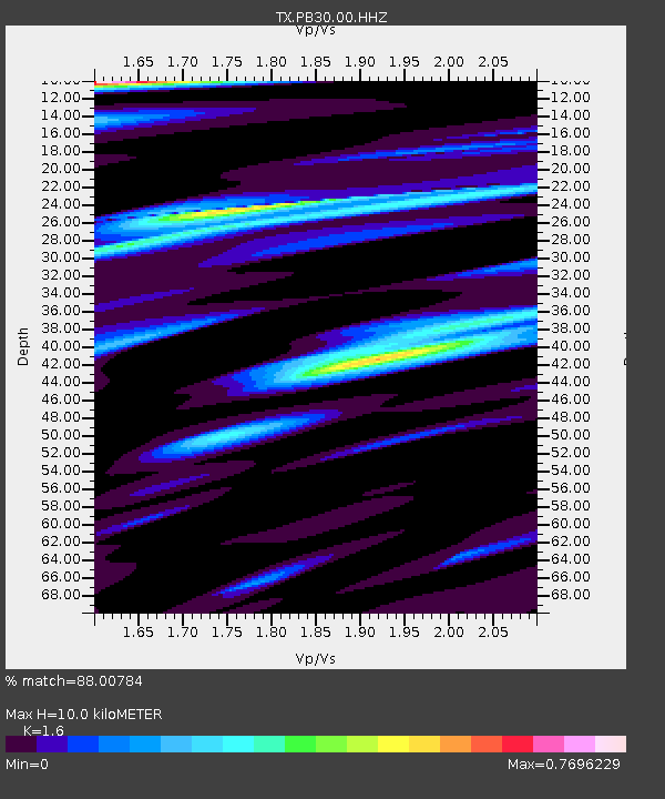
| Estimated Moho Depth: |
10.0 km |
| Estimated Crust Vp/Vs: |
1.60 |
| Assumed Crust Vp: |
6.121 km/s |
| Estimated Crust Vs: |
3.825 km/s |
| Estimated Crust Poisson's Ratio: |
0.18 |
|
| Radial Match: |
88.00784 % |
| Radial Bump: |
400 |
| Transverse Match: |
86.0009 % |
| Transverse Bump: |
400 |
| SOD ConfigId: |
34243671 |
| Insert Time: |
2024-05-01 17:37:30.036 +0000 |
| GWidth: |
2.5 |
| Max Bumps: |
400 |
| Tol: |
0.001 |
|

Signal To Noise
| Channel | StoN | STA | LTA |
| TX:PB30:00:HHZ:20221111T11:00:36.823985Z | 15.455047 | 5.4351785E-6 | 3.516766E-7 |
| TX:PB30:00:HHN:20221111T11:00:36.823985Z | 4.236208 | 8.2213154E-7 | 1.9407253E-7 |
| TX:PB30:00:HHE:20221111T11:00:36.823985Z | 2.9146874 | 7.689655E-7 | 2.6382435E-7 |
| Arrivals |
| Ps | 1.0 SECOND |
| PpPs | 4.1 SECOND |
| PsPs/PpSs | 5.1 SECOND |


