You are here: Home > Network List > TA - USArray Transportable Network (new EarthScope stations) Stations List
> Station 633A Saathoff Ranch, Hondo, TX, USA > Earthquake Result Viewer
633A Saathoff Ranch, Hondo, TX, USA - Earthquake Result Viewer
| Earthquake location: |
Off Coast Of Central Chile |
| Earthquake latitude/longitude: |
-34.7/-73.7 |
| Earthquake time(UTC): |
2010/10/21 (294) 02:49:56 GMT |
| Earthquake Depth: |
10 km |
| Earthquake Magnitude: |
5.9 MB, 5.5 MS, 5.9 MW, 5.8 MW |
| Earthquake Catalog/Contributor: |
WHDF/NEIC |
|
| Network: |
TA USArray Transportable Network (new EarthScope stations) |
| Station: |
633A Saathoff Ranch, Hondo, TX, USA |
| Lat/Lon: |
29.46 N/99.18 W |
| Elevation: |
320 m |
|
| Distance: |
68.2 deg |
| Az: |
336.194 deg |
| Baz: |
157.593 deg |
| Ray Param: |
0.05644266 |
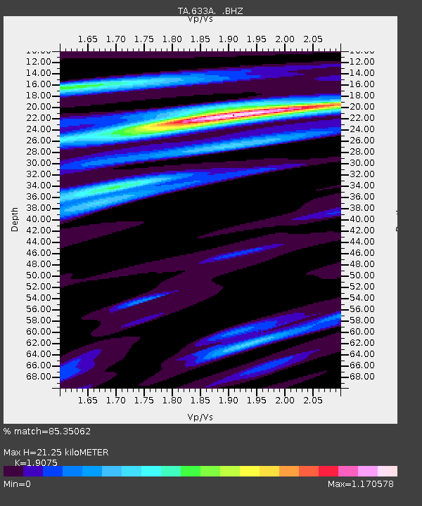
| Estimated Moho Depth: |
21.25 km |
| Estimated Crust Vp/Vs: |
1.91 |
| Assumed Crust Vp: |
6.347 km/s |
| Estimated Crust Vs: |
3.327 km/s |
| Estimated Crust Poisson's Ratio: |
0.31 |
|
| Radial Match: |
85.35062 % |
| Radial Bump: |
396 |
| Transverse Match: |
69.17121 % |
| Transverse Bump: |
400 |
| SOD ConfigId: |
339645 |
| Insert Time: |
2011-02-17 09:29:56.297 +0000 |
| GWidth: |
2.5 |
| Max Bumps: |
400 |
| Tol: |
0.001 |
|
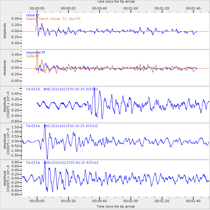
Signal To Noise
| Channel | StoN | STA | LTA |
| TA:633A: :BHZ:20101021T03:00:25.42501Z | 4.8719487 | 4.9067717E-7 | 1.00714765E-7 |
| TA:633A: :BHN:20101021T03:00:25.42501Z | 2.5267613 | 1.9888637E-7 | 7.871198E-8 |
| TA:633A: :BHE:20101021T03:00:25.42501Z | 1.2738625 | 9.88262E-8 | 7.7579955E-8 |
| Arrivals |
| Ps | 3.1 SECOND |
| PpPs | 9.4 SECOND |
| PsPs/PpSs | 13 SECOND |


