You are here: Home > Network List > TA - USArray Transportable Network (new EarthScope stations) Stations List
> Station 339A Huntington, TX, USA > Earthquake Result Viewer
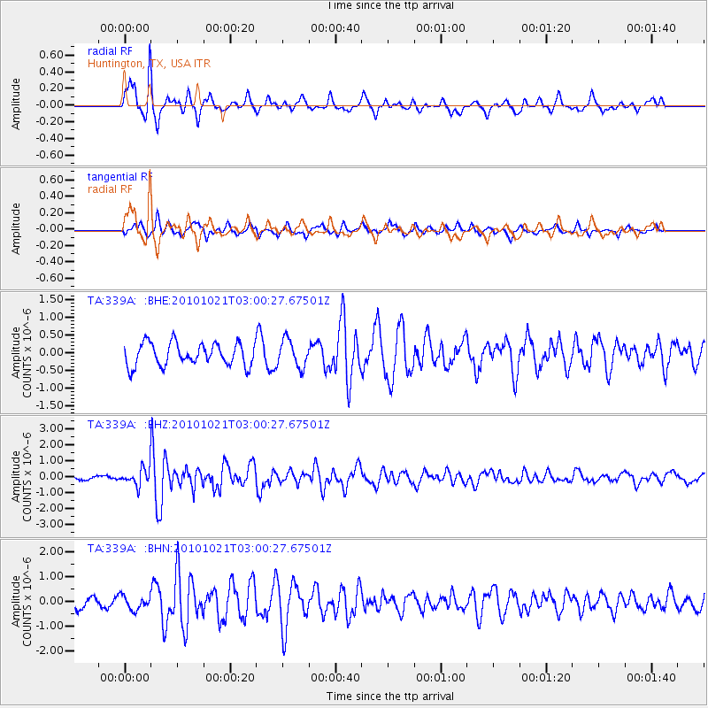
339A Huntington, TX, USA - Earthquake Result Viewer
*The percent match for this event was below the threshold and hence no stack was calculated.
| Earthquake location: |
Off Coast Of Central Chile |
| Earthquake latitude/longitude: |
-34.7/-73.7 |
| Earthquake time(UTC): |
2010/10/21 (294) 02:49:56 GMT |
| Earthquake Depth: |
10 km |
| Earthquake Magnitude: |
5.9 MB, 5.5 MS, 5.9 MW, 5.8 MW |
| Earthquake Catalog/Contributor: |
WHDF/NEIC |
|
| Network: |
TA USArray Transportable Network (new EarthScope stations) |
| Station: |
339A Huntington, TX, USA |
| Lat/Lon: |
31.33 N/94.56 W |
| Elevation: |
82 m |
|
| Distance: |
68.6 deg |
| Az: |
340.918 deg |
| Baz: |
161.661 deg |
| Ray Param: |
$rayparam |
*The percent match for this event was below the threshold and hence was not used in the summary stack. |
|
| Radial Match: |
78.04289 % |
| Radial Bump: |
357 |
| Transverse Match: |
44.03134 % |
| Transverse Bump: |
318 |
| SOD ConfigId: |
339645 |
| Insert Time: |
2011-02-17 09:30:47.818 +0000 |
| GWidth: |
2.5 |
| Max Bumps: |
400 |
| Tol: |
0.001 |
|
Signal To Noise
| Channel | StoN | STA | LTA |
| TA:339A: :BHZ:20101021T03:00:27.67501Z | 3.7873156 | 5.561106E-7 | 1.4683502E-7 |
| TA:339A: :BHN:20101021T03:00:27.67501Z | 0.84904987 | 2.819238E-7 | 3.320462E-7 |
| TA:339A: :BHE:20101021T03:00:27.67501Z | 1.2159104 | 3.8523672E-7 | 3.1682984E-7 |
| Arrivals |
| Ps | |
| PpPs | |
| PsPs/PpSs | |


