You are here: Home > Network List > AK - Alaska Regional Network Stations List
> Station M16K Timber Creek, AK, USA > Earthquake Result Viewer
M16K Timber Creek, AK, USA - Earthquake Result Viewer
| Earthquake location: |
Fiji Islands Region |
| Earthquake latitude/longitude: |
-20.1/-178.4 |
| Earthquake time(UTC): |
2022/11/12 (316) 07:09:14 GMT |
| Earthquake Depth: |
587 km |
| Earthquake Magnitude: |
7.0 mww |
| Earthquake Catalog/Contributor: |
NEIC PDE/us |
|
| Network: |
AK Alaska Regional Network |
| Station: |
M16K Timber Creek, AK, USA |
| Lat/Lon: |
61.02 N/158.96 W |
| Elevation: |
394 m |
|
| Distance: |
82.4 deg |
| Az: |
9.394 deg |
| Baz: |
198.361 deg |
| Ray Param: |
0.045189336 |
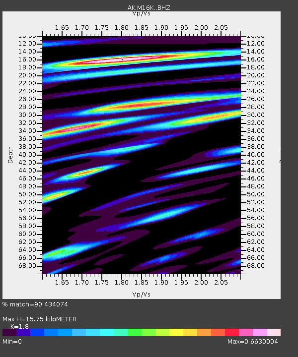
| Estimated Moho Depth: |
15.75 km |
| Estimated Crust Vp/Vs: |
1.80 |
| Assumed Crust Vp: |
6.276 km/s |
| Estimated Crust Vs: |
3.487 km/s |
| Estimated Crust Poisson's Ratio: |
0.28 |
|
| Radial Match: |
90.434074 % |
| Radial Bump: |
400 |
| Transverse Match: |
83.82427 % |
| Transverse Bump: |
400 |
| SOD ConfigId: |
34243671 |
| Insert Time: |
2024-05-01 18:13:07.077 +0000 |
| GWidth: |
2.5 |
| Max Bumps: |
400 |
| Tol: |
0.001 |
|

Signal To Noise
| Channel | StoN | STA | LTA |
| AK:M16K: :BHZ:20221112T07:20:04.059977Z | 26.173899 | 1.8273544E-5 | 6.9815906E-7 |
| AK:M16K: :BHN:20221112T07:20:04.059977Z | 10.07474 | 6.198872E-6 | 6.152885E-7 |
| AK:M16K: :BHE:20221112T07:20:04.059977Z | 1.8826588 | 1.9419688E-6 | 1.0315033E-6 |
| Arrivals |
| Ps | 2.1 SECOND |
| PpPs | 6.9 SECOND |
| PsPs/PpSs | 8.9 SECOND |


