You are here: Home > Network List > AK - Alaska Regional Network Stations List
> Station PS10 TAPS Pump Station 10, AK, USA > Earthquake Result Viewer
PS10 TAPS Pump Station 10, AK, USA - Earthquake Result Viewer
| Earthquake location: |
Fiji Islands Region |
| Earthquake latitude/longitude: |
-20.1/-178.4 |
| Earthquake time(UTC): |
2022/11/12 (316) 07:09:14 GMT |
| Earthquake Depth: |
587 km |
| Earthquake Magnitude: |
7.0 mww |
| Earthquake Catalog/Contributor: |
NEIC PDE/us |
|
| Network: |
AK Alaska Regional Network |
| Station: |
PS10 TAPS Pump Station 10, AK, USA |
| Lat/Lon: |
63.42 N/145.77 W |
| Elevation: |
738 m |
|
| Distance: |
87.1 deg |
| Az: |
14.041 deg |
| Baz: |
210.456 deg |
| Ray Param: |
0.041903425 |
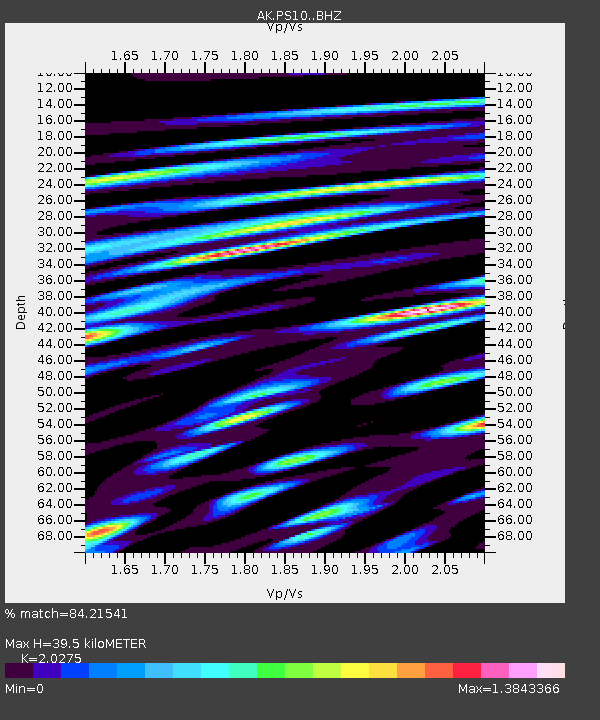
| Estimated Moho Depth: |
39.5 km |
| Estimated Crust Vp/Vs: |
2.03 |
| Assumed Crust Vp: |
6.566 km/s |
| Estimated Crust Vs: |
3.239 km/s |
| Estimated Crust Poisson's Ratio: |
0.34 |
|
| Radial Match: |
84.21541 % |
| Radial Bump: |
400 |
| Transverse Match: |
72.57162 % |
| Transverse Bump: |
400 |
| SOD ConfigId: |
34243671 |
| Insert Time: |
2024-05-01 18:13:49.426 +0000 |
| GWidth: |
2.5 |
| Max Bumps: |
400 |
| Tol: |
0.001 |
|

Signal To Noise
| Channel | StoN | STA | LTA |
| AK:PS10: :BHZ:20221112T07:20:26.960001Z | 20.443134 | 9.748562E-6 | 4.768624E-7 |
| AK:PS10: :BHN:20221112T07:20:26.960001Z | 11.536195 | 6.895797E-6 | 5.9775317E-7 |
| AK:PS10: :BHE:20221112T07:20:26.960001Z | 8.836284 | 3.7567286E-6 | 4.2514804E-7 |
| Arrivals |
| Ps | 6.3 SECOND |
| PpPs | 18 SECOND |
| PsPs/PpSs | 24 SECOND |


