You are here: Home > Network List > AK - Alaska Regional Network Stations List
> Station S31K Pelican, AK, USA > Earthquake Result Viewer
S31K Pelican, AK, USA - Earthquake Result Viewer
| Earthquake location: |
Fiji Islands Region |
| Earthquake latitude/longitude: |
-20.1/-178.4 |
| Earthquake time(UTC): |
2022/11/12 (316) 07:09:14 GMT |
| Earthquake Depth: |
587 km |
| Earthquake Magnitude: |
7.0 mww |
| Earthquake Catalog/Contributor: |
NEIC PDE/us |
|
| Network: |
AK Alaska Regional Network |
| Station: |
S31K Pelican, AK, USA |
| Lat/Lon: |
57.96 N/136.23 W |
| Elevation: |
34 m |
|
| Distance: |
85.3 deg |
| Az: |
21.026 deg |
| Baz: |
219.238 deg |
| Ray Param: |
0.04317524 |
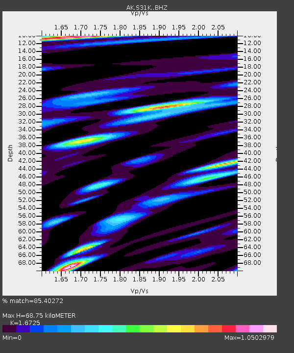
| Estimated Moho Depth: |
68.75 km |
| Estimated Crust Vp/Vs: |
1.67 |
| Assumed Crust Vp: |
6.134 km/s |
| Estimated Crust Vs: |
3.667 km/s |
| Estimated Crust Poisson's Ratio: |
0.22 |
|
| Radial Match: |
85.40272 % |
| Radial Bump: |
400 |
| Transverse Match: |
71.53274 % |
| Transverse Bump: |
400 |
| SOD ConfigId: |
34243671 |
| Insert Time: |
2024-05-01 18:14:07.710 +0000 |
| GWidth: |
2.5 |
| Max Bumps: |
400 |
| Tol: |
0.001 |
|

Signal To Noise
| Channel | StoN | STA | LTA |
| AK:S31K: :BHZ:20221112T07:20:18.400004Z | 15.146598 | 6.5126055E-6 | 4.2997152E-7 |
| AK:S31K: :BHN:20221112T07:20:18.400004Z | 7.0095105 | 2.3686543E-6 | 3.3792008E-7 |
| AK:S31K: :BHE:20221112T07:20:18.400004Z | 5.958604 | 1.8298613E-6 | 3.0709563E-7 |
| Arrivals |
| Ps | 7.7 SECOND |
| PpPs | 29 SECOND |
| PsPs/PpSs | 37 SECOND |


