You are here: Home > Network List > TA - USArray Transportable Network (new EarthScope stations) Stations List
> Station R36A Gordon, Harris, KS, USA > Earthquake Result Viewer
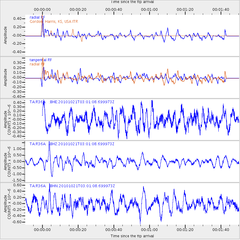
R36A Gordon, Harris, KS, USA - Earthquake Result Viewer
*The percent match for this event was below the threshold and hence no stack was calculated.
| Earthquake location: |
Off Coast Of Central Chile |
| Earthquake latitude/longitude: |
-34.7/-73.7 |
| Earthquake time(UTC): |
2010/10/21 (294) 02:49:56 GMT |
| Earthquake Depth: |
10 km |
| Earthquake Magnitude: |
5.9 MB, 5.5 MS, 5.9 MW, 5.8 MW |
| Earthquake Catalog/Contributor: |
WHDF/NEIC |
|
| Network: |
TA USArray Transportable Network (new EarthScope stations) |
| Station: |
R36A Gordon, Harris, KS, USA |
| Lat/Lon: |
38.32 N/95.50 W |
| Elevation: |
354 m |
|
| Distance: |
75.4 deg |
| Az: |
342.449 deg |
| Baz: |
161.594 deg |
| Ray Param: |
$rayparam |
*The percent match for this event was below the threshold and hence was not used in the summary stack. |
|
| Radial Match: |
55.702236 % |
| Radial Bump: |
400 |
| Transverse Match: |
59.8976 % |
| Transverse Bump: |
400 |
| SOD ConfigId: |
339645 |
| Insert Time: |
2011-02-17 09:31:57.372 +0000 |
| GWidth: |
2.5 |
| Max Bumps: |
400 |
| Tol: |
0.001 |
|
Signal To Noise
| Channel | StoN | STA | LTA |
| TA:R36A: :BHZ:20101021T03:01:08.699973Z | 3.145627 | 5.496564E-7 | 1.7473667E-7 |
| TA:R36A: :BHN:20101021T03:01:08.699973Z | 1.9046932 | 2.2707403E-7 | 1.1921816E-7 |
| TA:R36A: :BHE:20101021T03:01:08.699973Z | 0.80798453 | 1.2353306E-7 | 1.5289037E-7 |
| Arrivals |
| Ps | |
| PpPs | |
| PsPs/PpSs | |


