You are here: Home > Network List > TA - USArray Transportable Network (new EarthScope stations) Stations List
> Station Y37A Hugo, OK, USA > Earthquake Result Viewer
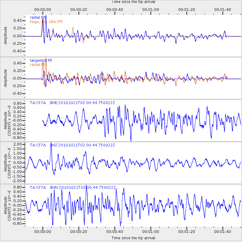
Y37A Hugo, OK, USA - Earthquake Result Viewer
*The percent match for this event was below the threshold and hence no stack was calculated.
| Earthquake location: |
Off Coast Of Central Chile |
| Earthquake latitude/longitude: |
-34.7/-73.7 |
| Earthquake time(UTC): |
2010/10/21 (294) 02:49:56 GMT |
| Earthquake Depth: |
10 km |
| Earthquake Magnitude: |
5.9 MB, 5.5 MS, 5.9 MW, 5.8 MW |
| Earthquake Catalog/Contributor: |
WHDF/NEIC |
|
| Network: |
TA USArray Transportable Network (new EarthScope stations) |
| Station: |
Y37A Hugo, OK, USA |
| Lat/Lon: |
33.98 N/95.62 W |
| Elevation: |
165 m |
|
| Distance: |
71.4 deg |
| Az: |
340.908 deg |
| Baz: |
161.085 deg |
| Ray Param: |
$rayparam |
*The percent match for this event was below the threshold and hence was not used in the summary stack. |
|
| Radial Match: |
70.381645 % |
| Radial Bump: |
400 |
| Transverse Match: |
54.932808 % |
| Transverse Bump: |
400 |
| SOD ConfigId: |
339645 |
| Insert Time: |
2011-02-17 09:32:43.169 +0000 |
| GWidth: |
2.5 |
| Max Bumps: |
400 |
| Tol: |
0.001 |
|
Signal To Noise
| Channel | StoN | STA | LTA |
| TA:Y37A: :BHZ:20101021T03:00:44.750022Z | 1.7235607 | 6.809617E-7 | 3.9509004E-7 |
| TA:Y37A: :BHN:20101021T03:00:44.750022Z | 0.9156963 | 2.2484063E-7 | 2.455406E-7 |
| TA:Y37A: :BHE:20101021T03:00:44.750022Z | 1.1732222 | 2.418174E-7 | 2.061139E-7 |
| Arrivals |
| Ps | |
| PpPs | |
| PsPs/PpSs | |


