You are here: Home > Network List > TA - USArray Transportable Network (new EarthScope stations) Stations List
> Station 136A Ennis, TX, USA > Earthquake Result Viewer
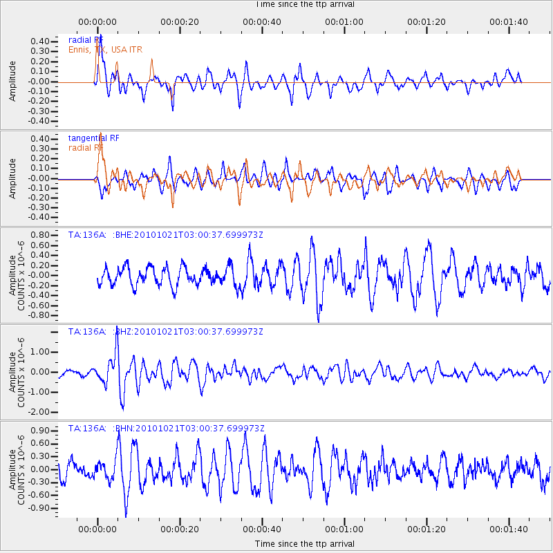
136A Ennis, TX, USA - Earthquake Result Viewer
*The percent match for this event was below the threshold and hence no stack was calculated.
| Earthquake location: |
Off Coast Of Central Chile |
| Earthquake latitude/longitude: |
-34.7/-73.7 |
| Earthquake time(UTC): |
2010/10/21 (294) 02:49:56 GMT |
| Earthquake Depth: |
10 km |
| Earthquake Magnitude: |
5.9 MB, 5.5 MS, 5.9 MW, 5.8 MW |
| Earthquake Catalog/Contributor: |
WHDF/NEIC |
|
| Network: |
TA USArray Transportable Network (new EarthScope stations) |
| Station: |
136A Ennis, TX, USA |
| Lat/Lon: |
32.47 N/96.53 W |
| Elevation: |
113 m |
|
| Distance: |
70.2 deg |
| Az: |
339.62 deg |
| Baz: |
160.166 deg |
| Ray Param: |
$rayparam |
*The percent match for this event was below the threshold and hence was not used in the summary stack. |
|
| Radial Match: |
77.87196 % |
| Radial Bump: |
400 |
| Transverse Match: |
70.79875 % |
| Transverse Bump: |
400 |
| SOD ConfigId: |
339645 |
| Insert Time: |
2011-02-17 09:34:39.601 +0000 |
| GWidth: |
2.5 |
| Max Bumps: |
400 |
| Tol: |
0.001 |
|
Signal To Noise
| Channel | StoN | STA | LTA |
| TA:136A: :BHZ:20101021T03:00:37.699973Z | 4.925771 | 7.61016E-7 | 1.5449682E-7 |
| TA:136A: :BHN:20101021T03:00:37.699973Z | 1.3553436 | 2.2570426E-7 | 1.6652918E-7 |
| TA:136A: :BHE:20101021T03:00:37.699973Z | 1.1063309 | 1.9889198E-7 | 1.7977622E-7 |
| Arrivals |
| Ps | |
| PpPs | |
| PsPs/PpSs | |


