You are here: Home > Network List > TA - USArray Transportable Network (new EarthScope stations) Stations List
> Station K35A Storm Lake, IA, USA > Earthquake Result Viewer
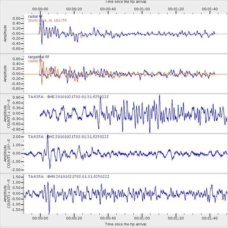
K35A Storm Lake, IA, USA - Earthquake Result Viewer
*The percent match for this event was below the threshold and hence no stack was calculated.
| Earthquake location: |
Off Coast Of Central Chile |
| Earthquake latitude/longitude: |
-34.7/-73.7 |
| Earthquake time(UTC): |
2010/10/21 (294) 02:49:56 GMT |
| Earthquake Depth: |
10 km |
| Earthquake Magnitude: |
5.9 MB, 5.5 MS, 5.9 MW, 5.8 MW |
| Earthquake Catalog/Contributor: |
WHDF/NEIC |
|
| Network: |
TA USArray Transportable Network (new EarthScope stations) |
| Station: |
K35A Storm Lake, IA, USA |
| Lat/Lon: |
42.72 N/95.23 W |
| Elevation: |
439 m |
|
| Distance: |
79.6 deg |
| Az: |
344.052 deg |
| Baz: |
162.117 deg |
| Ray Param: |
$rayparam |
*The percent match for this event was below the threshold and hence was not used in the summary stack. |
|
| Radial Match: |
65.897835 % |
| Radial Bump: |
400 |
| Transverse Match: |
67.31483 % |
| Transverse Bump: |
400 |
| SOD ConfigId: |
339645 |
| Insert Time: |
2011-02-17 09:36:33.614 +0000 |
| GWidth: |
2.5 |
| Max Bumps: |
400 |
| Tol: |
0.001 |
|
Signal To Noise
| Channel | StoN | STA | LTA |
| TA:K35A: :BHZ:20101021T03:01:31.625022Z | 3.9540179 | 7.195804E-7 | 1.8198715E-7 |
| TA:K35A: :BHN:20101021T03:01:31.625022Z | 2.4578645 | 4.5823253E-7 | 1.8643524E-7 |
| TA:K35A: :BHE:20101021T03:01:31.625022Z | 1.4967384 | 3.0595126E-7 | 2.0441199E-7 |
| Arrivals |
| Ps | |
| PpPs | |
| PsPs/PpSs | |


