You are here: Home > Network List > KZ - Kazakhstan Network Stations List
> Station MAKZ Makanchi, Kazakstan > Earthquake Result Viewer
MAKZ Makanchi, Kazakstan - Earthquake Result Viewer
| Earthquake location: |
Near S. Coast Of Honshu, Japan |
| Earthquake latitude/longitude: |
33.8/137.3 |
| Earthquake time(UTC): |
2022/11/14 (318) 08:08:26 GMT |
| Earthquake Depth: |
357 km |
| Earthquake Magnitude: |
6.1 mww |
| Earthquake Catalog/Contributor: |
NEIC PDE/us |
|
| Network: |
KZ Kazakhstan Network |
| Station: |
MAKZ Makanchi, Kazakstan |
| Lat/Lon: |
46.81 N/81.98 E |
| Elevation: |
600 m |
|
| Distance: |
43.3 deg |
| Az: |
304.535 deg |
| Baz: |
87.018 deg |
| Ray Param: |
0.07111229 |
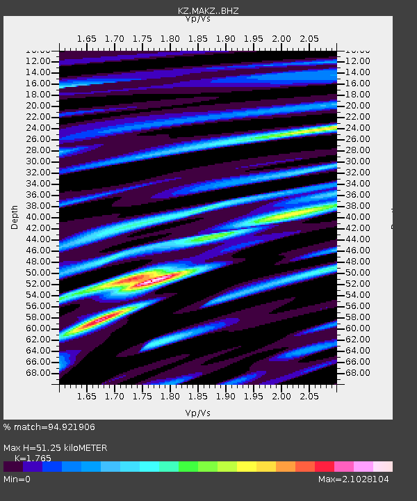
| Estimated Moho Depth: |
51.25 km |
| Estimated Crust Vp/Vs: |
1.76 |
| Assumed Crust Vp: |
6.571 km/s |
| Estimated Crust Vs: |
3.723 km/s |
| Estimated Crust Poisson's Ratio: |
0.26 |
|
| Radial Match: |
94.921906 % |
| Radial Bump: |
400 |
| Transverse Match: |
85.22086 % |
| Transverse Bump: |
400 |
| SOD ConfigId: |
34243671 |
| Insert Time: |
2024-05-01 19:22:08.468 +0000 |
| GWidth: |
2.5 |
| Max Bumps: |
400 |
| Tol: |
0.001 |
|

Signal To Noise
| Channel | StoN | STA | LTA |
| KZ:MAKZ: :BHZ:20221114T08:15:23.994002Z | 253.98741 | 4.716959E-6 | 1.8571626E-8 |
| KZ:MAKZ: :BHN:20221114T08:15:23.994002Z | 23.852917 | 1.3441281E-6 | 5.6350682E-8 |
| KZ:MAKZ: :BHE:20221114T08:15:23.994002Z | 128.55766 | 4.7329117E-6 | 3.681548E-8 |
| Arrivals |
| Ps | 6.4 SECOND |
| PpPs | 20 SECOND |
| PsPs/PpSs | 27 SECOND |


