You are here: Home > Network List > TA - USArray Transportable Network (new EarthScope stations) Stations List
> Station G35A Watkins, MN, USA > Earthquake Result Viewer
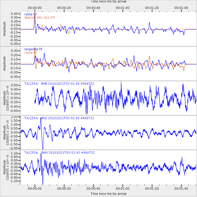
G35A Watkins, MN, USA - Earthquake Result Viewer
*The percent match for this event was below the threshold and hence no stack was calculated.
| Earthquake location: |
Off Coast Of Central Chile |
| Earthquake latitude/longitude: |
-34.7/-73.7 |
| Earthquake time(UTC): |
2010/10/21 (294) 02:49:56 GMT |
| Earthquake Depth: |
10 km |
| Earthquake Magnitude: |
5.9 MB, 5.5 MS, 5.9 MW, 5.8 MW |
| Earthquake Catalog/Contributor: |
WHDF/NEIC |
|
| Network: |
TA USArray Transportable Network (new EarthScope stations) |
| Station: |
G35A Watkins, MN, USA |
| Lat/Lon: |
45.22 N/94.49 W |
| Elevation: |
361 m |
|
| Distance: |
81.8 deg |
| Az: |
345.335 deg |
| Baz: |
162.842 deg |
| Ray Param: |
$rayparam |
*The percent match for this event was below the threshold and hence was not used in the summary stack. |
|
| Radial Match: |
48.76729 % |
| Radial Bump: |
400 |
| Transverse Match: |
66.41039 % |
| Transverse Bump: |
400 |
| SOD ConfigId: |
339645 |
| Insert Time: |
2011-02-17 09:39:13.122 +0000 |
| GWidth: |
2.5 |
| Max Bumps: |
400 |
| Tol: |
0.001 |
|
Signal To Noise
| Channel | StoN | STA | LTA |
| TA:G35A: :BHZ:20101021T03:01:43.449973Z | 2.512068 | 7.1906305E-7 | 2.8624345E-7 |
| TA:G35A: :BHN:20101021T03:01:43.449973Z | 2.9004388 | 4.5574248E-7 | 1.5712881E-7 |
| TA:G35A: :BHE:20101021T03:01:43.449973Z | 0.88248116 | 2.1766732E-7 | 2.466538E-7 |
| Arrivals |
| Ps | |
| PpPs | |
| PsPs/PpSs | |


