You are here: Home > Network List > XG92 - Rocky Mountain Front Stations List
> Station GRM Grand Mesa, CO > Earthquake Result Viewer
GRM Grand Mesa, CO - Earthquake Result Viewer
| Earthquake location: |
Southeast Of Honshu, Japan |
| Earthquake latitude/longitude: |
32.8/141.8 |
| Earthquake time(UTC): |
1992/08/12 (225) 06:36:12 GMT |
| Earthquake Depth: |
33 km |
| Earthquake Magnitude: |
5.5 MB, 5.6 MS |
| Earthquake Catalog/Contributor: |
WHDF/NEIC |
|
| Network: |
XG Rocky Mountain Front |
| Station: |
GRM Grand Mesa, CO |
| Lat/Lon: |
39.10 N/108.13 W |
| Elevation: |
2112 m |
|
| Distance: |
83.5 deg |
| Az: |
47.345 deg |
| Baz: |
307.243 deg |
| Ray Param: |
0.04610601 |
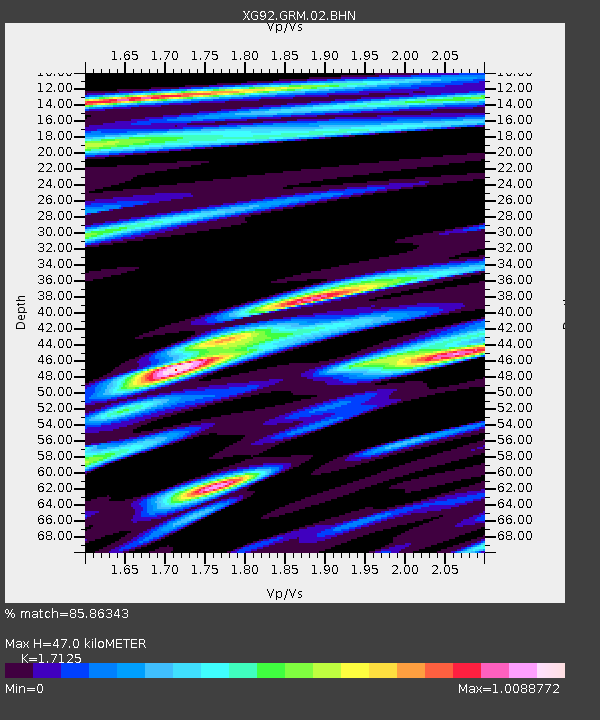
| Estimated Moho Depth: |
47.0 km |
| Estimated Crust Vp/Vs: |
1.71 |
| Assumed Crust Vp: |
6.291 km/s |
| Estimated Crust Vs: |
3.673 km/s |
| Estimated Crust Poisson's Ratio: |
0.24 |
|
| Radial Match: |
85.86343 % |
| Radial Bump: |
400 |
| Transverse Match: |
75.79399 % |
| Transverse Bump: |
400 |
| SOD ConfigId: |
3286 |
| Insert Time: |
2010-02-25 20:08:40.677 +0000 |
| GWidth: |
2.5 |
| Max Bumps: |
400 |
| Tol: |
0.001 |
|

Signal To Noise
| Channel | StoN | STA | LTA |
| XG:GRM:02:BHN:19920812T06:48:05.652014Z | 0.5704453 | 4.5152297E-5 | 7.915272E-5 |
| XG:GRM:02:BHE:19920812T06:48:05.652014Z | 1.5409728 | 9.539046E-5 | 6.190275E-5 |
| XG:GRM:02:BHZ:19920812T06:48:05.652014Z | 0.850845 | 6.715909E-5 | 7.893223E-5 |
| Arrivals |
| Ps | 5.5 SECOND |
| PpPs | 20 SECOND |
| PsPs/PpSs | 25 SECOND |


