You are here: Home > Network List > II - Global Seismograph Network (GSN - IRIS/IDA) Stations List
> Station NNA Nana, Peru > Earthquake Result Viewer
NNA Nana, Peru - Earthquake Result Viewer
| Earthquake location: |
Gulf Of California |
| Earthquake latitude/longitude: |
24.7/-109.2 |
| Earthquake time(UTC): |
2010/10/21 (294) 17:53:13 GMT |
| Earthquake Depth: |
10 km |
| Earthquake Magnitude: |
6.2 MB, 6.8 MS, 6.7 MW, 6.7 MW |
| Earthquake Catalog/Contributor: |
WHDF/NEIC |
|
| Network: |
II Global Seismograph Network (GSN - IRIS/IDA) |
| Station: |
NNA Nana, Peru |
| Lat/Lon: |
11.99 S/76.84 W |
| Elevation: |
575 m |
|
| Distance: |
48.2 deg |
| Az: |
135.441 deg |
| Baz: |
319.286 deg |
| Ray Param: |
0.069508746 |
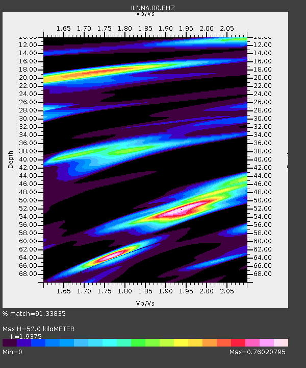
| Estimated Moho Depth: |
52.0 km |
| Estimated Crust Vp/Vs: |
1.94 |
| Assumed Crust Vp: |
6.472 km/s |
| Estimated Crust Vs: |
3.34 km/s |
| Estimated Crust Poisson's Ratio: |
0.32 |
|
| Radial Match: |
91.33835 % |
| Radial Bump: |
378 |
| Transverse Match: |
85.72749 % |
| Transverse Bump: |
400 |
| SOD ConfigId: |
339645 |
| Insert Time: |
2011-02-17 09:44:48.568 +0000 |
| GWidth: |
2.5 |
| Max Bumps: |
400 |
| Tol: |
0.001 |
|
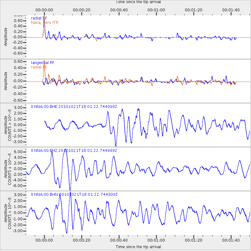
Signal To Noise
| Channel | StoN | STA | LTA |
| II:NNA:00:BHZ:20101021T18:01:22.744999Z | 3.536566 | 2.6879413E-6 | 7.600427E-7 |
| II:NNA:00:BHN:20101021T18:01:22.744999Z | 4.0102963 | 1.2597033E-6 | 3.1411727E-7 |
| II:NNA:00:BHE:20101021T18:01:22.744999Z | 1.8253776 | 9.1491825E-7 | 5.012214E-7 |
| Arrivals |
| Ps | 8.0 SECOND |
| PpPs | 22 SECOND |
| PsPs/PpSs | 30 SECOND |


