You are here: Home > Network List > TX - Texas Seismological Network Stations List
> Station FW05 UT at Dallas > Earthquake Result Viewer
FW05 UT at Dallas - Earthquake Result Viewer
| Earthquake location: |
Samoa Islands Region |
| Earthquake latitude/longitude: |
-15.4/-173.0 |
| Earthquake time(UTC): |
2022/12/04 (338) 19:24:15 GMT |
| Earthquake Depth: |
36 km |
| Earthquake Magnitude: |
6.7 Mww |
| Earthquake Catalog/Contributor: |
NEIC PDE/us |
|
| Network: |
TX Texas Seismological Network |
| Station: |
FW05 UT at Dallas |
| Lat/Lon: |
32.99 N/96.75 W |
| Elevation: |
207 m |
|
| Distance: |
87.1 deg |
| Az: |
54.814 deg |
| Baz: |
249.714 deg |
| Ray Param: |
0.04349909 |
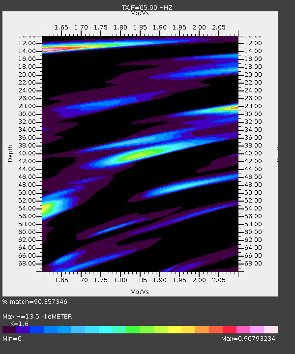
| Estimated Moho Depth: |
13.5 km |
| Estimated Crust Vp/Vs: |
1.60 |
| Assumed Crust Vp: |
6.38 km/s |
| Estimated Crust Vs: |
3.988 km/s |
| Estimated Crust Poisson's Ratio: |
0.18 |
|
| Radial Match: |
90.357346 % |
| Radial Bump: |
400 |
| Transverse Match: |
87.62394 % |
| Transverse Bump: |
400 |
| SOD ConfigId: |
34243671 |
| Insert Time: |
2024-05-02 02:17:51.645 +0000 |
| GWidth: |
2.5 |
| Max Bumps: |
400 |
| Tol: |
0.001 |
|

Signal To Noise
| Channel | StoN | STA | LTA |
| TX:FW05:00:HHZ:20221204T19:36:26.066012Z | 12.9096155 | 3.5364112E-6 | 2.7393622E-7 |
| TX:FW05:00:HHN:20221204T19:36:26.066012Z | 2.1331987 | 6.314267E-7 | 2.9599994E-7 |
| TX:FW05:00:HHE:20221204T19:36:26.066012Z | 2.3991907 | 1.0443157E-6 | 4.3527834E-7 |
| Arrivals |
| Ps | 1.3 SECOND |
| PpPs | 5.4 SECOND |
| PsPs/PpSs | 6.7 SECOND |


