You are here: Home > Network List > TX - Texas Seismological Network Stations List
> Station FW06 Azle > Earthquake Result Viewer
FW06 Azle - Earthquake Result Viewer
| Earthquake location: |
Samoa Islands Region |
| Earthquake latitude/longitude: |
-15.4/-173.0 |
| Earthquake time(UTC): |
2022/12/04 (338) 19:24:15 GMT |
| Earthquake Depth: |
36 km |
| Earthquake Magnitude: |
6.7 Mww |
| Earthquake Catalog/Contributor: |
NEIC PDE/us |
|
| Network: |
TX Texas Seismological Network |
| Station: |
FW06 Azle |
| Lat/Lon: |
32.97 N/97.56 W |
| Elevation: |
233 m |
|
| Distance: |
86.5 deg |
| Az: |
54.59 deg |
| Baz: |
249.263 deg |
| Ray Param: |
0.043970164 |
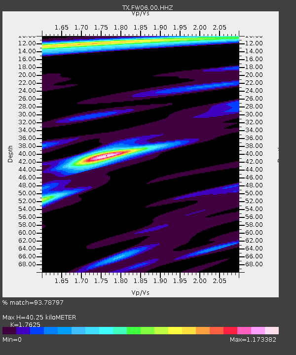
| Estimated Moho Depth: |
40.25 km |
| Estimated Crust Vp/Vs: |
1.76 |
| Assumed Crust Vp: |
6.38 km/s |
| Estimated Crust Vs: |
3.62 km/s |
| Estimated Crust Poisson's Ratio: |
0.26 |
|
| Radial Match: |
93.78797 % |
| Radial Bump: |
384 |
| Transverse Match: |
90.23409 % |
| Transverse Bump: |
389 |
| SOD ConfigId: |
34243671 |
| Insert Time: |
2024-05-02 02:17:53.407 +0000 |
| GWidth: |
2.5 |
| Max Bumps: |
400 |
| Tol: |
0.001 |
|

Signal To Noise
| Channel | StoN | STA | LTA |
| TX:FW06:00:HHZ:20221204T19:36:22.944002Z | 15.636977 | 3.8079718E-6 | 2.4352352E-7 |
| TX:FW06:00:HHN:20221204T19:36:22.944002Z | 4.6134176 | 7.8736844E-7 | 1.7066922E-7 |
| TX:FW06:00:HHE:20221204T19:36:22.944002Z | 3.8124988 | 7.233199E-7 | 1.8972331E-7 |
| Arrivals |
| Ps | 4.9 SECOND |
| PpPs | 17 SECOND |
| PsPs/PpSs | 22 SECOND |


