You are here: Home > Network List > TX - Texas Seismological Network Stations List
> Station FW14 Avarado > Earthquake Result Viewer
FW14 Avarado - Earthquake Result Viewer
| Earthquake location: |
Samoa Islands Region |
| Earthquake latitude/longitude: |
-15.4/-173.0 |
| Earthquake time(UTC): |
2022/12/04 (338) 19:24:15 GMT |
| Earthquake Depth: |
36 km |
| Earthquake Magnitude: |
6.7 Mww |
| Earthquake Catalog/Contributor: |
NEIC PDE/us |
|
| Network: |
TX Texas Seismological Network |
| Station: |
FW14 Avarado |
| Lat/Lon: |
32.40 N/97.19 W |
| Elevation: |
219 m |
|
| Distance: |
86.6 deg |
| Az: |
55.234 deg |
| Baz: |
249.498 deg |
| Ray Param: |
0.04390777 |
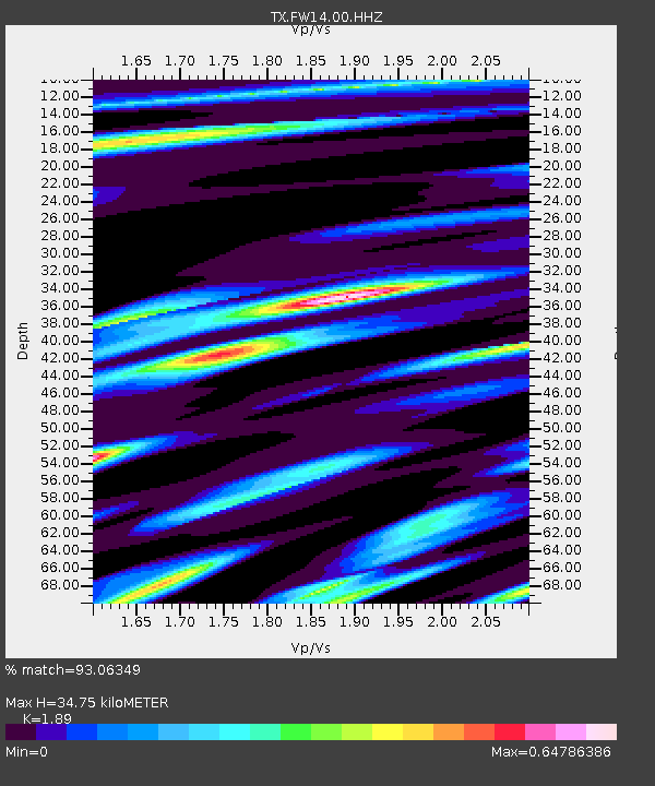
| Estimated Moho Depth: |
34.75 km |
| Estimated Crust Vp/Vs: |
1.89 |
| Assumed Crust Vp: |
6.38 km/s |
| Estimated Crust Vs: |
3.376 km/s |
| Estimated Crust Poisson's Ratio: |
0.31 |
|
| Radial Match: |
93.06349 % |
| Radial Bump: |
400 |
| Transverse Match: |
92.49957 % |
| Transverse Bump: |
400 |
| SOD ConfigId: |
34243671 |
| Insert Time: |
2024-05-02 02:18:03.948 +0000 |
| GWidth: |
2.5 |
| Max Bumps: |
400 |
| Tol: |
0.001 |
|

Signal To Noise
| Channel | StoN | STA | LTA |
| TX:FW14:00:HHZ:20221204T19:36:23.365023Z | 19.317667 | 3.7535335E-6 | 1.9430573E-7 |
| TX:FW14:00:HHN:20221204T19:36:23.365023Z | 4.4127994 | 1.0698565E-6 | 2.4244392E-7 |
| TX:FW14:00:HHE:20221204T19:36:23.365023Z | 5.798384 | 9.607085E-7 | 1.6568553E-7 |
| Arrivals |
| Ps | 5.0 SECOND |
| PpPs | 15 SECOND |
| PsPs/PpSs | 20 SECOND |


