You are here: Home > Network List > TX - Texas Seismological Network Stations List
> Station MB06 Greenwood, TX > Earthquake Result Viewer
MB06 Greenwood, TX - Earthquake Result Viewer
| Earthquake location: |
Samoa Islands Region |
| Earthquake latitude/longitude: |
-15.4/-173.0 |
| Earthquake time(UTC): |
2022/12/04 (338) 19:24:15 GMT |
| Earthquake Depth: |
36 km |
| Earthquake Magnitude: |
6.7 Mww |
| Earthquake Catalog/Contributor: |
NEIC PDE/us |
|
| Network: |
TX Texas Seismological Network |
| Station: |
MB06 Greenwood, TX |
| Lat/Lon: |
31.98 N/101.80 W |
| Elevation: |
801 m |
|
| Distance: |
82.8 deg |
| Az: |
54.171 deg |
| Baz: |
246.956 deg |
| Ray Param: |
0.046598736 |
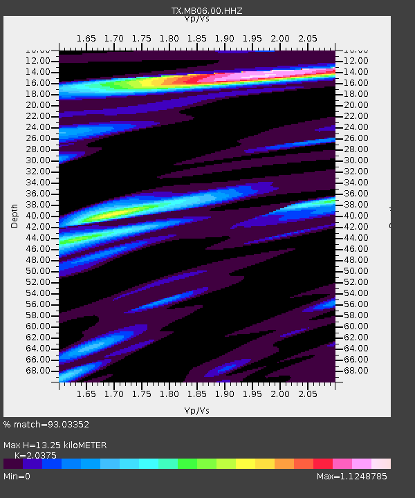
| Estimated Moho Depth: |
13.25 km |
| Estimated Crust Vp/Vs: |
2.04 |
| Assumed Crust Vp: |
6.38 km/s |
| Estimated Crust Vs: |
3.132 km/s |
| Estimated Crust Poisson's Ratio: |
0.34 |
|
| Radial Match: |
93.03352 % |
| Radial Bump: |
400 |
| Transverse Match: |
82.19399 % |
| Transverse Bump: |
400 |
| SOD ConfigId: |
34243671 |
| Insert Time: |
2024-05-02 02:18:08.630 +0000 |
| GWidth: |
2.5 |
| Max Bumps: |
400 |
| Tol: |
0.001 |
|

Signal To Noise
| Channel | StoN | STA | LTA |
| TX:MB06:00:HHZ:20221204T19:36:04.360018Z | 15.857417 | 4.1871826E-6 | 2.64052E-7 |
| TX:MB06:00:HHN:20221204T19:36:04.360018Z | 2.8086143 | 5.4928785E-7 | 1.9557254E-7 |
| TX:MB06:00:HHE:20221204T19:36:04.360018Z | 8.675849 | 1.6144933E-6 | 1.8609052E-7 |
| Arrivals |
| Ps | 2.2 SECOND |
| PpPs | 6.2 SECOND |
| PsPs/PpSs | 8.4 SECOND |


