You are here: Home > Network List > TX - Texas Seismological Network Stations List
> Station PB31 Salt Creek > Earthquake Result Viewer
PB31 Salt Creek - Earthquake Result Viewer
| Earthquake location: |
Samoa Islands Region |
| Earthquake latitude/longitude: |
-15.4/-173.0 |
| Earthquake time(UTC): |
2022/12/04 (338) 19:24:15 GMT |
| Earthquake Depth: |
36 km |
| Earthquake Magnitude: |
6.7 Mww |
| Earthquake Catalog/Contributor: |
NEIC PDE/us |
|
| Network: |
TX Texas Seismological Network |
| Station: |
PB31 Salt Creek |
| Lat/Lon: |
31.73 N/104.03 W |
| Elevation: |
907 m |
|
| Distance: |
81.0 deg |
| Az: |
53.628 deg |
| Baz: |
245.707 deg |
| Ray Param: |
0.047879096 |
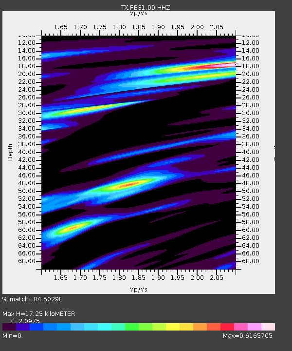
| Estimated Moho Depth: |
17.25 km |
| Estimated Crust Vp/Vs: |
2.10 |
| Assumed Crust Vp: |
6.361 km/s |
| Estimated Crust Vs: |
3.032 km/s |
| Estimated Crust Poisson's Ratio: |
0.35 |
|
| Radial Match: |
84.50298 % |
| Radial Bump: |
400 |
| Transverse Match: |
84.11282 % |
| Transverse Bump: |
400 |
| SOD ConfigId: |
34243671 |
| Insert Time: |
2024-05-02 02:18:22.483 +0000 |
| GWidth: |
2.5 |
| Max Bumps: |
400 |
| Tol: |
0.001 |
|

Signal To Noise
| Channel | StoN | STA | LTA |
| TX:PB31:00:HHZ:20221204T19:35:54.740023Z | 8.15722 | 4.1486987E-6 | 5.085922E-7 |
| TX:PB31:00:HH1:20221204T19:35:54.740023Z | 4.046057 | 8.3571473E-7 | 2.065504E-7 |
| TX:PB31:00:HH2:20221204T19:35:54.740023Z | 3.6543517 | 1.5093822E-6 | 4.1303693E-7 |
| Arrivals |
| Ps | 3.0 SECOND |
| PpPs | 8.2 SECOND |
| PsPs/PpSs | 11 SECOND |


