You are here: Home > Network List > YX16 - Raton Basin UNM Broadband Network Stations List
> Station UNM4 NW Corner of NM Stations > Earthquake Result Viewer
UNM4 NW Corner of NM Stations - Earthquake Result Viewer
| Earthquake location: |
Samoa Islands Region |
| Earthquake latitude/longitude: |
-15.4/-173.0 |
| Earthquake time(UTC): |
2022/12/04 (338) 19:24:15 GMT |
| Earthquake Depth: |
36 km |
| Earthquake Magnitude: |
6.7 Mww |
| Earthquake Catalog/Contributor: |
NEIC PDE/us |
|
| Network: |
YX Raton Basin UNM Broadband Network |
| Station: |
UNM4 NW Corner of NM Stations |
| Lat/Lon: |
36.99 N/105.06 W |
| Elevation: |
2784 m |
|
| Distance: |
82.4 deg |
| Az: |
48.458 deg |
| Baz: |
244.381 deg |
| Ray Param: |
0.046866514 |
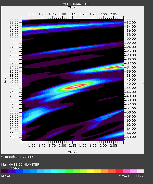
| Estimated Moho Depth: |
33.25 km |
| Estimated Crust Vp/Vs: |
2.10 |
| Assumed Crust Vp: |
6.316 km/s |
| Estimated Crust Vs: |
3.015 km/s |
| Estimated Crust Poisson's Ratio: |
0.35 |
|
| Radial Match: |
94.77839 % |
| Radial Bump: |
381 |
| Transverse Match: |
83.60611 % |
| Transverse Bump: |
400 |
| SOD ConfigId: |
34243671 |
| Insert Time: |
2024-05-02 02:20:10.203 +0000 |
| GWidth: |
2.5 |
| Max Bumps: |
400 |
| Tol: |
0.001 |
|

Signal To Noise
| Channel | StoN | STA | LTA |
| YX:UNM4: :HHZ:20221204T19:36:02.31003Z | 22.021746 | 3.653249E-6 | 1.658928E-7 |
| YX:UNM4: :HHN:20221204T19:36:02.31003Z | 1.8433292 | 5.5410965E-7 | 3.0060264E-7 |
| YX:UNM4: :HHE:20221204T19:36:02.31003Z | 3.0046399 | 8.4509554E-7 | 2.812635E-7 |
| Arrivals |
| Ps | 5.9 SECOND |
| PpPs | 16 SECOND |
| PsPs/PpSs | 22 SECOND |


