You are here: Home > Network List > YT07 - POLENET Stations List
> Station WAIS WAIS > Earthquake Result Viewer
WAIS WAIS - Earthquake Result Viewer
| Earthquake location: |
Santa Cruz Islands |
| Earthquake latitude/longitude: |
-11.3/166.2 |
| Earthquake time(UTC): |
2022/12/05 (339) 05:35:08 GMT |
| Earthquake Depth: |
93 km |
| Earthquake Magnitude: |
5.7 mww |
| Earthquake Catalog/Contributor: |
NEIC PDE/us |
|
| Network: |
YT POLENET |
| Station: |
WAIS WAIS |
| Lat/Lon: |
79.42 S/111.78 W |
| Elevation: |
1800 m |
|
| Distance: |
77.5 deg |
| Az: |
169.192 deg |
| Baz: |
275.749 deg |
| Ray Param: |
0.050102305 |
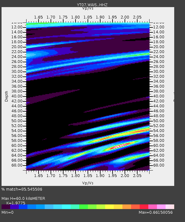
| Estimated Moho Depth: |
60.0 km |
| Estimated Crust Vp/Vs: |
1.98 |
| Assumed Crust Vp: |
5.833 km/s |
| Estimated Crust Vs: |
2.95 km/s |
| Estimated Crust Poisson's Ratio: |
0.33 |
|
| Radial Match: |
85.545586 % |
| Radial Bump: |
400 |
| Transverse Match: |
86.75942 % |
| Transverse Bump: |
400 |
| SOD ConfigId: |
34243671 |
| Insert Time: |
2024-05-02 02:34:40.122 +0000 |
| GWidth: |
2.5 |
| Max Bumps: |
400 |
| Tol: |
0.001 |
|

Signal To Noise
| Channel | StoN | STA | LTA |
| YT:WAIS: :HHZ:20221205T05:46:22.958973Z | 12.521302 | 8.310858E-7 | 6.637375E-8 |
| YT:WAIS: :HHN:20221205T05:46:22.958973Z | 1.0624609 | 4.632501E-8 | 4.3601613E-8 |
| YT:WAIS: :HHE:20221205T05:46:22.958973Z | 2.6703813 | 1.0299516E-7 | 3.8569457E-8 |
| Arrivals |
| Ps | 10 SECOND |
| PpPs | 30 SECOND |
| PsPs/PpSs | 40 SECOND |


