You are here: Home > Network List > YT07 - POLENET Stations List
> Station WAIS WAIS > Earthquake Result Viewer
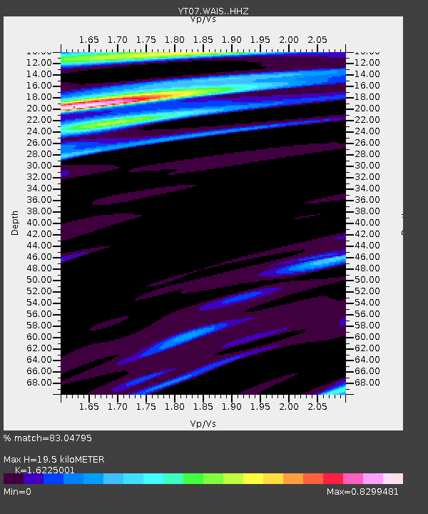
WAIS WAIS - Earthquake Result Viewer
| Earthquake location: |
Tonga Islands |
| Earthquake latitude/longitude: |
-15.2/-173.1 |
| Earthquake time(UTC): |
2022/12/05 (339) 16:19:19 GMT |
| Earthquake Depth: |
10 km |
| Earthquake Magnitude: |
5.6 Mww |
| Earthquake Catalog/Contributor: |
NEIC PDE/us |
|
| Network: |
YT POLENET |
| Station: |
WAIS WAIS |
| Lat/Lon: |
79.42 S/111.78 W |
| Elevation: |
1800 m |
|
| Distance: |
70.0 deg |
| Az: |
170.061 deg |
| Baz: |
295.649 deg |
| Ray Param: |
0.055286516 |
| Estimated Moho Depth: |
19.5 km |
| Estimated Crust Vp/Vs: |
1.62 |
| Assumed Crust Vp: |
5.833 km/s |
| Estimated Crust Vs: |
3.595 km/s |
| Estimated Crust Poisson's Ratio: |
0.19 |
|
| Radial Match: |
83.04795 % |
| Radial Bump: |
400 |
| Transverse Match: |
87.09018 % |
| Transverse Bump: |
400 |
| SOD ConfigId: |
34243671 |
| Insert Time: |
2024-05-02 02:52:54.161 +0000 |
| GWidth: |
2.5 |
| Max Bumps: |
400 |
| Tol: |
0.001 |
|

Signal To Noise
| Channel | StoN | STA | LTA |
| YT:WAIS: :HHZ:20221205T16:30:00.319016Z | 8.831235 | 7.677898E-7 | 8.6940254E-8 |
| YT:WAIS: :HHN:20221205T16:30:00.319016Z | 1.6688263 | 9.203976E-8 | 5.515239E-8 |
| YT:WAIS: :HHE:20221205T16:30:00.319016Z | 3.230806 | 1.5237194E-7 | 4.7162207E-8 |
| Arrivals |
| Ps | 2.2 SECOND |
| PpPs | 8.5 SECOND |
| PsPs/PpSs | 11 SECOND |


