You are here: Home > Network List > US - United States National Seismic Network Stations List
> Station LONY Lake Ozonia, New York, USA > Earthquake Result Viewer
LONY Lake Ozonia, New York, USA - Earthquake Result Viewer
| Earthquake location: |
Gulf Of California |
| Earthquake latitude/longitude: |
24.7/-109.2 |
| Earthquake time(UTC): |
2010/10/21 (294) 17:53:13 GMT |
| Earthquake Depth: |
10 km |
| Earthquake Magnitude: |
6.2 MB, 6.8 MS, 6.7 MW, 6.7 MW |
| Earthquake Catalog/Contributor: |
WHDF/NEIC |
|
| Network: |
US United States National Seismic Network |
| Station: |
LONY Lake Ozonia, New York, USA |
| Lat/Lon: |
44.62 N/74.58 W |
| Elevation: |
440 m |
|
| Distance: |
34.3 deg |
| Az: |
45.918 deg |
| Baz: |
246.204 deg |
| Ray Param: |
0.07778949 |
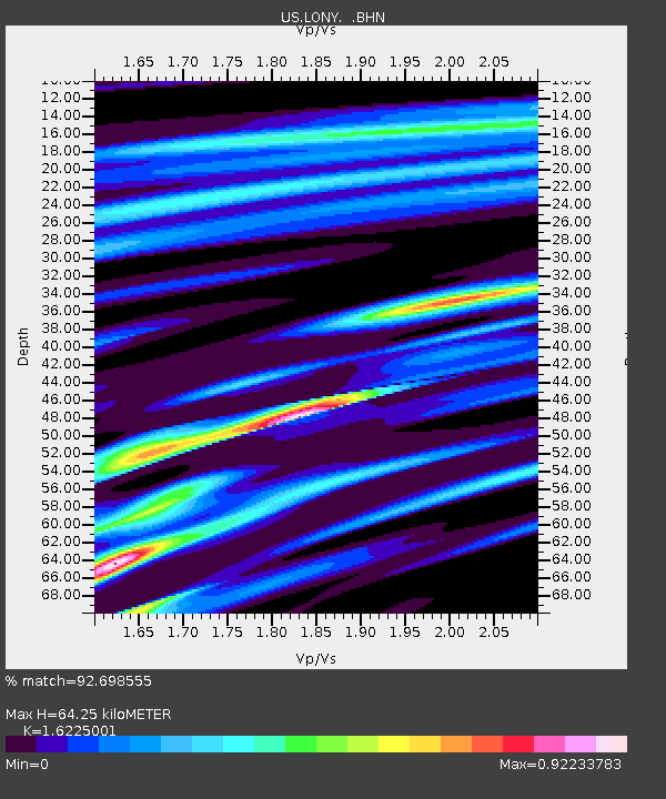
| Estimated Moho Depth: |
64.25 km |
| Estimated Crust Vp/Vs: |
1.62 |
| Assumed Crust Vp: |
6.419 km/s |
| Estimated Crust Vs: |
3.956 km/s |
| Estimated Crust Poisson's Ratio: |
0.19 |
|
| Radial Match: |
92.698555 % |
| Radial Bump: |
335 |
| Transverse Match: |
76.709236 % |
| Transverse Bump: |
400 |
| SOD ConfigId: |
339645 |
| Insert Time: |
2011-02-17 09:47:04.404 +0000 |
| GWidth: |
2.5 |
| Max Bumps: |
400 |
| Tol: |
0.001 |
|

Signal To Noise
| Channel | StoN | STA | LTA |
| US:LONY: :BHZ:20101021T17:59:29.149998Z | 4.3505163 | 5.797979E-7 | 1.3327106E-7 |
| US:LONY: :BHN:20101021T17:59:29.149998Z | 2.2256951 | 3.490646E-7 | 1.5683398E-7 |
| US:LONY: :BHE:20101021T17:59:29.149998Z | 2.0211792 | 4.108081E-7 | 2.032517E-7 |
| Arrivals |
| Ps | 6.8 SECOND |
| PpPs | 24 SECOND |
| PsPs/PpSs | 31 SECOND |


