You are here: Home > Network List > XG92 - Rocky Mountain Front Stations List
> Station GRM Grand Mesa, CO > Earthquake Result Viewer
GRM Grand Mesa, CO - Earthquake Result Viewer
| Earthquake location: |
Svalbard Region |
| Earthquake latitude/longitude: |
78.5/5.1 |
| Earthquake time(UTC): |
1992/07/20 (202) 07:46:46 GMT |
| Earthquake Depth: |
10 km |
| Earthquake Magnitude: |
5.8 MB, 6.3 MS |
| Earthquake Catalog/Contributor: |
WHDF/NEIC |
|
| Network: |
XG Rocky Mountain Front |
| Station: |
GRM Grand Mesa, CO |
| Lat/Lon: |
39.10 N/108.13 W |
| Elevation: |
2112 m |
|
| Distance: |
56.4 deg |
| Az: |
300.804 deg |
| Baz: |
12.833 deg |
| Ray Param: |
0.06417788 |
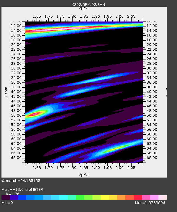
| Estimated Moho Depth: |
13.0 km |
| Estimated Crust Vp/Vs: |
1.76 |
| Assumed Crust Vp: |
6.291 km/s |
| Estimated Crust Vs: |
3.574 km/s |
| Estimated Crust Poisson's Ratio: |
0.26 |
|
| Radial Match: |
94.185135 % |
| Radial Bump: |
346 |
| Transverse Match: |
85.23263 % |
| Transverse Bump: |
400 |
| SOD ConfigId: |
3286 |
| Insert Time: |
2010-02-25 20:08:42.069 +0000 |
| GWidth: |
2.5 |
| Max Bumps: |
400 |
| Tol: |
0.001 |
|

Signal To Noise
| Channel | StoN | STA | LTA |
| XG:GRM:02:BHN:19920720T07:55:56.909021Z | 0.54434186 | 6.390629E-5 | 1.1740102E-4 |
| XG:GRM:02:BHE:19920720T07:55:56.909021Z | 1.2606485 | 1.0384934E-4 | 8.2377715E-5 |
| XG:GRM:02:BHZ:19920720T07:55:56.909021Z | 1.3838066 | 1.10891706E-4 | 8.0135265E-5 |
| Arrivals |
| Ps | 1.6 SECOND |
| PpPs | 5.4 SECOND |
| PsPs/PpSs | 7.1 SECOND |


