You are here: Home > Network List > AK - Alaska Regional Network Stations List
> Station E22K Anaktuvuk Pass, AK, USA > Earthquake Result Viewer
E22K Anaktuvuk Pass, AK, USA - Earthquake Result Viewer
| Earthquake location: |
Ryukyu Islands, Japan |
| Earthquake latitude/longitude: |
27.5/129.6 |
| Earthquake time(UTC): |
2022/12/13 (347) 14:25:15 GMT |
| Earthquake Depth: |
10 km |
| Earthquake Magnitude: |
5.7 mww |
| Earthquake Catalog/Contributor: |
NEIC PDE/us |
|
| Network: |
AK Alaska Regional Network |
| Station: |
E22K Anaktuvuk Pass, AK, USA |
| Lat/Lon: |
68.13 N/151.81 W |
| Elevation: |
772 m |
|
| Distance: |
60.5 deg |
| Az: |
24.947 deg |
| Baz: |
270.655 deg |
| Ray Param: |
0.0614771 |
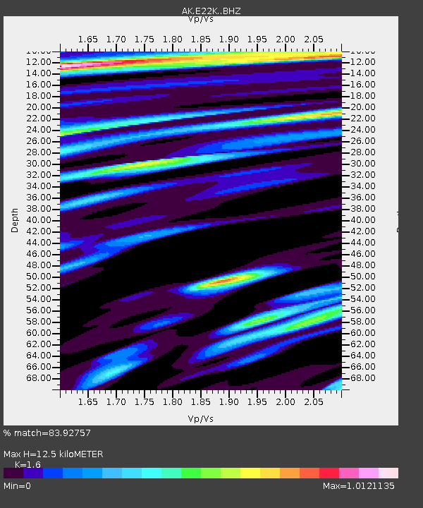
| Estimated Moho Depth: |
12.5 km |
| Estimated Crust Vp/Vs: |
1.60 |
| Assumed Crust Vp: |
6.221 km/s |
| Estimated Crust Vs: |
3.888 km/s |
| Estimated Crust Poisson's Ratio: |
0.18 |
|
| Radial Match: |
83.92757 % |
| Radial Bump: |
400 |
| Transverse Match: |
72.396866 % |
| Transverse Bump: |
400 |
| SOD ConfigId: |
34243671 |
| Insert Time: |
2024-05-02 06:08:48.968 +0000 |
| GWidth: |
2.5 |
| Max Bumps: |
400 |
| Tol: |
0.001 |
|

Signal To Noise
| Channel | StoN | STA | LTA |
| AK:E22K: :BHZ:20221213T14:34:55.240Z | 2.425785 | 3.8280885E-7 | 1.5780823E-7 |
| AK:E22K: :BHN:20221213T14:34:55.240Z | 0.7286936 | 1.2842756E-7 | 1.7624356E-7 |
| AK:E22K: :BHE:20221213T14:34:55.240Z | 0.940182 | 2.0685438E-7 | 2.2001525E-7 |
| Arrivals |
| Ps | 1.3 SECOND |
| PpPs | 5.0 SECOND |
| PsPs/PpSs | 6.2 SECOND |


