You are here: Home > Network List > IW - Intermountain West Stations List
> Station MOOW Moose Ponds, Wyoming, USA > Earthquake Result Viewer
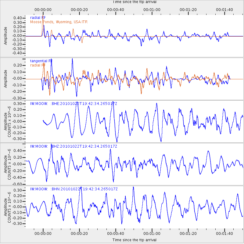
MOOW Moose Ponds, Wyoming, USA - Earthquake Result Viewer
*The percent match for this event was below the threshold and hence no stack was calculated.
| Earthquake location: |
Chile-Bolivia Border Region |
| Earthquake latitude/longitude: |
-20.9/-68.4 |
| Earthquake time(UTC): |
2010/10/22 (295) 19:31:37 GMT |
| Earthquake Depth: |
132 km |
| Earthquake Magnitude: |
5.8 MW, 5.4 MB, 5.8 MW |
| Earthquake Catalog/Contributor: |
WHDF/NEIC |
|
| Network: |
IW Intermountain West |
| Station: |
MOOW Moose Ponds, Wyoming, USA |
| Lat/Lon: |
43.75 N/110.74 W |
| Elevation: |
2128 m |
|
| Distance: |
75.1 deg |
| Az: |
329.647 deg |
| Baz: |
139.303 deg |
| Ray Param: |
$rayparam |
*The percent match for this event was below the threshold and hence was not used in the summary stack. |
|
| Radial Match: |
64.60094 % |
| Radial Bump: |
400 |
| Transverse Match: |
60.77711 % |
| Transverse Bump: |
400 |
| SOD ConfigId: |
339645 |
| Insert Time: |
2011-02-24 07:39:28.393 +0000 |
| GWidth: |
2.5 |
| Max Bumps: |
400 |
| Tol: |
0.001 |
|
Signal To Noise
| Channel | StoN | STA | LTA |
| IW:MOOW: :BHZ:20101022T19:42:34.265017Z | 2.1413589 | 2.827661E-7 | 1.3204985E-7 |
| IW:MOOW: :BHN:20101022T19:42:34.265017Z | 1.2026831 | 9.88429E-8 | 8.218532E-8 |
| IW:MOOW: :BHE:20101022T19:42:34.265017Z | 0.58829206 | 7.9954E-8 | 1.3590868E-7 |
| Arrivals |
| Ps | |
| PpPs | |
| PsPs/PpSs | |


