You are here: Home > Network List > YX16 - Raton Basin UNM Broadband Network Stations List
> Station UNM1 NE Corner of NM Stations > Earthquake Result Viewer
UNM1 NE Corner of NM Stations - Earthquake Result Viewer
| Earthquake location: |
Rat Islands, Aleutian Islands |
| Earthquake latitude/longitude: |
51.6/178.6 |
| Earthquake time(UTC): |
2022/12/14 (348) 18:40:26 GMT |
| Earthquake Depth: |
73 km |
| Earthquake Magnitude: |
6.3 Mww |
| Earthquake Catalog/Contributor: |
NEIC PDE/us |
|
| Network: |
YX Raton Basin UNM Broadband Network |
| Station: |
UNM1 NE Corner of NM Stations |
| Lat/Lon: |
36.96 N/104.82 W |
| Elevation: |
2470 m |
|
| Distance: |
54.3 deg |
| Az: |
73.704 deg |
| Baz: |
311.662 deg |
| Ray Param: |
0.06536832 |
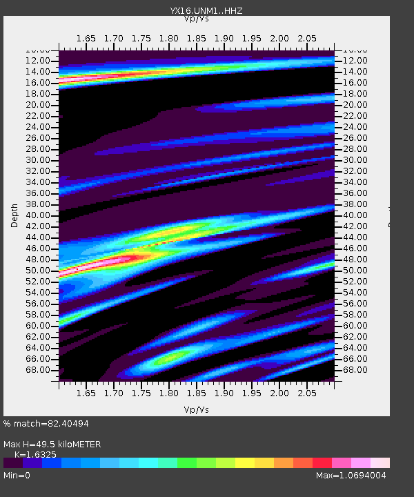
| Estimated Moho Depth: |
49.5 km |
| Estimated Crust Vp/Vs: |
1.63 |
| Assumed Crust Vp: |
6.316 km/s |
| Estimated Crust Vs: |
3.869 km/s |
| Estimated Crust Poisson's Ratio: |
0.20 |
|
| Radial Match: |
82.40494 % |
| Radial Bump: |
364 |
| Transverse Match: |
61.009804 % |
| Transverse Bump: |
400 |
| SOD ConfigId: |
34243671 |
| Insert Time: |
2024-05-02 06:45:53.710 +0000 |
| GWidth: |
2.5 |
| Max Bumps: |
400 |
| Tol: |
0.001 |
|

Signal To Noise
| Channel | StoN | STA | LTA |
| YX:UNM1: :HHZ:20221214T18:49:14.660019Z | 19.365273 | 5.111393E-6 | 2.6394636E-7 |
| YX:UNM1: :HHN:20221214T18:49:14.660019Z | 5.4704146 | 1.8309195E-6 | 3.3469482E-7 |
| YX:UNM1: :HHE:20221214T18:49:14.660019Z | 7.6152086 | 1.9663655E-6 | 2.5821558E-7 |
| Arrivals |
| Ps | 5.2 SECOND |
| PpPs | 20 SECOND |
| PsPs/PpSs | 25 SECOND |


