You are here: Home > Network List > TA - USArray Transportable Network (new EarthScope stations) Stations List
> Station R31A Burdett, KS, USA > Earthquake Result Viewer
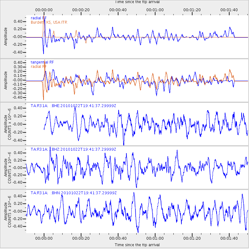
R31A Burdett, KS, USA - Earthquake Result Viewer
*The percent match for this event was below the threshold and hence no stack was calculated.
| Earthquake location: |
Chile-Bolivia Border Region |
| Earthquake latitude/longitude: |
-20.9/-68.4 |
| Earthquake time(UTC): |
2010/10/22 (295) 19:31:37 GMT |
| Earthquake Depth: |
132 km |
| Earthquake Magnitude: |
5.8 MW, 5.4 MB, 5.8 MW |
| Earthquake Catalog/Contributor: |
WHDF/NEIC |
|
| Network: |
TA USArray Transportable Network (new EarthScope stations) |
| Station: |
R31A Burdett, KS, USA |
| Lat/Lon: |
38.29 N/99.53 W |
| Elevation: |
667 m |
|
| Distance: |
65.7 deg |
| Az: |
333.474 deg |
| Baz: |
147.946 deg |
| Ray Param: |
$rayparam |
*The percent match for this event was below the threshold and hence was not used in the summary stack. |
|
| Radial Match: |
42.902405 % |
| Radial Bump: |
400 |
| Transverse Match: |
69.33374 % |
| Transverse Bump: |
400 |
| SOD ConfigId: |
339645 |
| Insert Time: |
2011-02-24 07:45:00.574 +0000 |
| GWidth: |
2.5 |
| Max Bumps: |
400 |
| Tol: |
0.001 |
|
Signal To Noise
| Channel | StoN | STA | LTA |
| TA:R31A: :BHZ:20101022T19:41:37.29999Z | 2.209381 | 2.4783594E-7 | 1.12174384E-7 |
| TA:R31A: :BHN:20101022T19:41:37.29999Z | 0.83043504 | 1.0954021E-7 | 1.3190703E-7 |
| TA:R31A: :BHE:20101022T19:41:37.29999Z | 0.5728596 | 9.3570705E-8 | 1.6333969E-7 |
| Arrivals |
| Ps | |
| PpPs | |
| PsPs/PpSs | |


