You are here: Home > Network List > YT07 - POLENET Stations List
> Station UNGL UNGL > Earthquake Result Viewer
UNGL UNGL - Earthquake Result Viewer
| Earthquake location: |
Vanuatu Islands |
| Earthquake latitude/longitude: |
-14.9/166.9 |
| Earthquake time(UTC): |
2023/01/08 (008) 12:32:42 GMT |
| Earthquake Depth: |
28 km |
| Earthquake Magnitude: |
7.0 mww |
| Earthquake Catalog/Contributor: |
NEIC PDE/us |
|
| Network: |
YT POLENET |
| Station: |
UNGL UNGL |
| Lat/Lon: |
79.77 S/82.52 W |
| Elevation: |
745 m |
|
| Distance: |
79.0 deg |
| Az: |
170.189 deg |
| Baz: |
247.199 deg |
| Ray Param: |
0.04924531 |
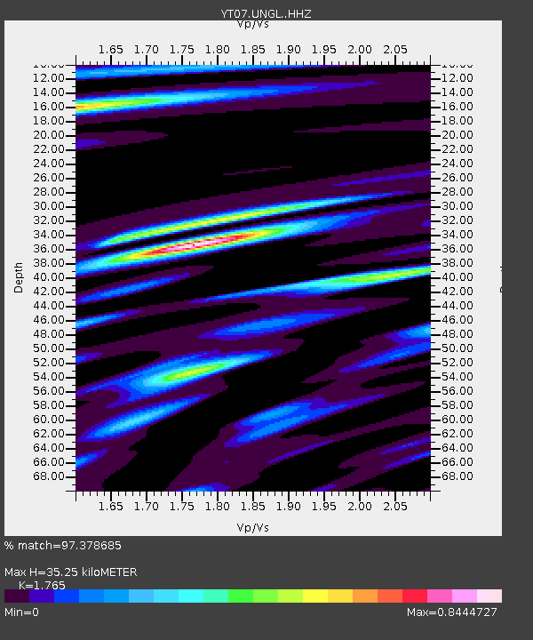
| Estimated Moho Depth: |
35.25 km |
| Estimated Crust Vp/Vs: |
1.76 |
| Assumed Crust Vp: |
6.182 km/s |
| Estimated Crust Vs: |
3.502 km/s |
| Estimated Crust Poisson's Ratio: |
0.26 |
|
| Radial Match: |
97.378685 % |
| Radial Bump: |
400 |
| Transverse Match: |
91.219894 % |
| Transverse Bump: |
400 |
| SOD ConfigId: |
34243671 |
| Insert Time: |
2024-05-02 12:02:58.321 +0000 |
| GWidth: |
2.5 |
| Max Bumps: |
400 |
| Tol: |
0.001 |
|

Signal To Noise
| Channel | StoN | STA | LTA |
| YT:UNGL: :HHZ:20230108T12:44:12.119024Z | 14.425636 | 3.3985698E-6 | 2.3559237E-7 |
| YT:UNGL: :HHN:20230108T12:44:12.119024Z | 2.6816604 | 5.4573644E-7 | 2.0350691E-7 |
| YT:UNGL: :HHE:20230108T12:44:12.119024Z | 6.9816976 | 1.1610738E-6 | 1.6630251E-7 |
| Arrivals |
| Ps | 4.5 SECOND |
| PpPs | 15 SECOND |
| PsPs/PpSs | 20 SECOND |


