You are here: Home > Network List > TA - USArray Transportable Network (new EarthScope stations) Stations List
> Station 340A Bronson, TX, USA > Earthquake Result Viewer
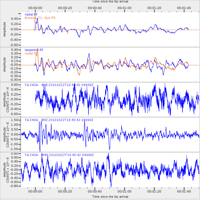
340A Bronson, TX, USA - Earthquake Result Viewer
*The percent match for this event was below the threshold and hence no stack was calculated.
| Earthquake location: |
Chile-Bolivia Border Region |
| Earthquake latitude/longitude: |
-20.9/-68.4 |
| Earthquake time(UTC): |
2010/10/22 (295) 19:31:37 GMT |
| Earthquake Depth: |
132 km |
| Earthquake Magnitude: |
5.8 MW, 5.4 MB, 5.8 MW |
| Earthquake Catalog/Contributor: |
WHDF/NEIC |
|
| Network: |
TA USArray Transportable Network (new EarthScope stations) |
| Station: |
340A Bronson, TX, USA |
| Lat/Lon: |
31.42 N/93.89 W |
| Elevation: |
57 m |
|
| Distance: |
57.5 deg |
| Az: |
334.098 deg |
| Baz: |
151.458 deg |
| Ray Param: |
$rayparam |
*The percent match for this event was below the threshold and hence was not used in the summary stack. |
|
| Radial Match: |
47.582256 % |
| Radial Bump: |
400 |
| Transverse Match: |
50.5372 % |
| Transverse Bump: |
400 |
| SOD ConfigId: |
339645 |
| Insert Time: |
2011-02-24 07:51:57.711 +0000 |
| GWidth: |
2.5 |
| Max Bumps: |
400 |
| Tol: |
0.001 |
|
Signal To Noise
| Channel | StoN | STA | LTA |
| TA:340A: :BHZ:20101022T19:40:42.04999Z | 4.8023744 | 7.41754E-7 | 1.5445568E-7 |
| TA:340A: :BHN:20101022T19:40:42.04999Z | 1.1607457 | 2.7918372E-7 | 2.40521E-7 |
| TA:340A: :BHE:20101022T19:40:42.04999Z | 1.2303588 | 2.602316E-7 | 2.1150868E-7 |
| Arrivals |
| Ps | |
| PpPs | |
| PsPs/PpSs | |


