You are here: Home > Network List > TA - USArray Transportable Network (new EarthScope stations) Stations List
> Station Y37A Hugo, OK, USA > Earthquake Result Viewer
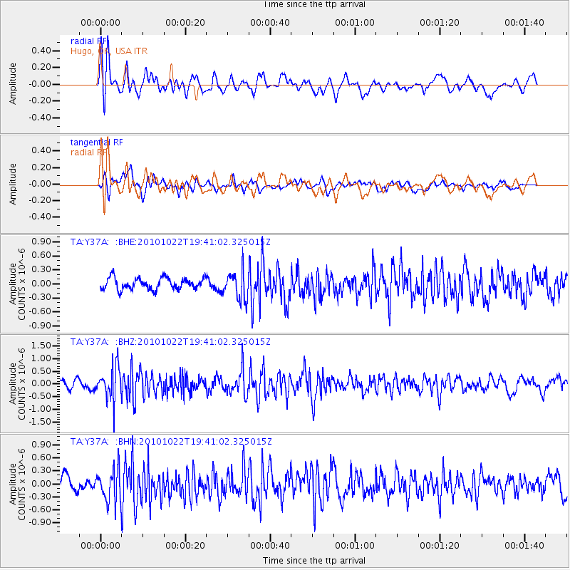
Y37A Hugo, OK, USA - Earthquake Result Viewer
*The percent match for this event was below the threshold and hence no stack was calculated.
| Earthquake location: |
Chile-Bolivia Border Region |
| Earthquake latitude/longitude: |
-20.9/-68.4 |
| Earthquake time(UTC): |
2010/10/22 (295) 19:31:37 GMT |
| Earthquake Depth: |
132 km |
| Earthquake Magnitude: |
5.8 MW, 5.4 MB, 5.8 MW |
| Earthquake Catalog/Contributor: |
WHDF/NEIC |
|
| Network: |
TA USArray Transportable Network (new EarthScope stations) |
| Station: |
Y37A Hugo, OK, USA |
| Lat/Lon: |
33.98 N/95.62 W |
| Elevation: |
165 m |
|
| Distance: |
60.4 deg |
| Az: |
334.054 deg |
| Baz: |
150.504 deg |
| Ray Param: |
$rayparam |
*The percent match for this event was below the threshold and hence was not used in the summary stack. |
|
| Radial Match: |
70.30509 % |
| Radial Bump: |
400 |
| Transverse Match: |
56.61172 % |
| Transverse Bump: |
400 |
| SOD ConfigId: |
339645 |
| Insert Time: |
2011-02-24 07:53:48.746 +0000 |
| GWidth: |
2.5 |
| Max Bumps: |
400 |
| Tol: |
0.001 |
|
Signal To Noise
| Channel | StoN | STA | LTA |
| TA:Y37A: :BHZ:20101022T19:41:02.325015Z | 3.2998066 | 6.353253E-7 | 1.9253412E-7 |
| TA:Y37A: :BHN:20101022T19:41:02.325015Z | 1.6230091 | 3.754547E-7 | 2.3133248E-7 |
| TA:Y37A: :BHE:20101022T19:41:02.325015Z | 2.5120225 | 3.0405315E-7 | 1.2103918E-7 |
| Arrivals |
| Ps | |
| PpPs | |
| PsPs/PpSs | |


