You are here: Home > Network List > TA - USArray Transportable Network (new EarthScope stations) Stations List
> Station X38A Whitesboro, OK, USA > Earthquake Result Viewer
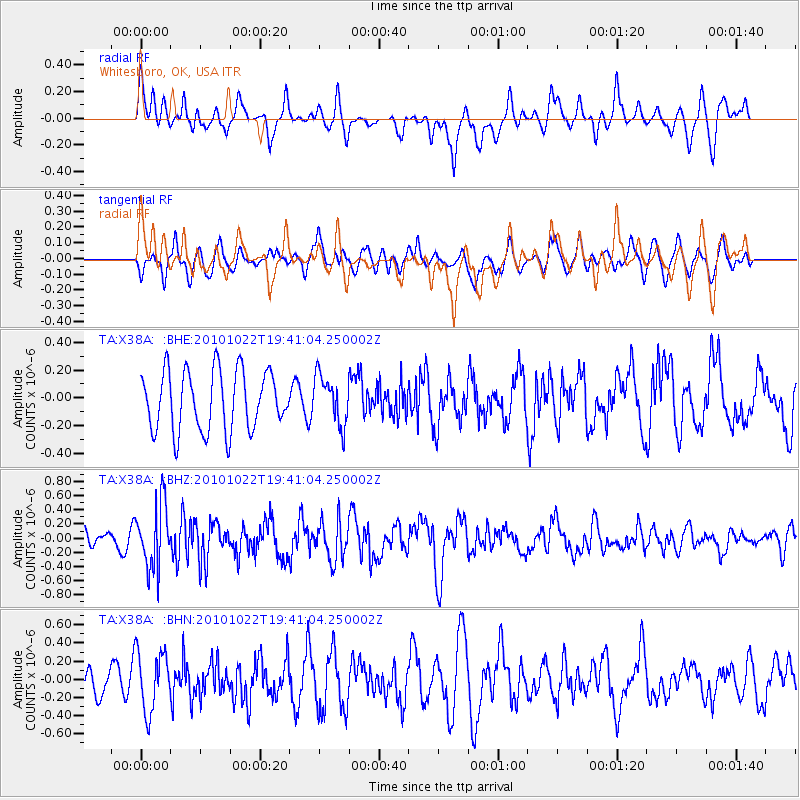
X38A Whitesboro, OK, USA - Earthquake Result Viewer
*The percent match for this event was below the threshold and hence no stack was calculated.
| Earthquake location: |
Chile-Bolivia Border Region |
| Earthquake latitude/longitude: |
-20.9/-68.4 |
| Earthquake time(UTC): |
2010/10/22 (295) 19:31:37 GMT |
| Earthquake Depth: |
132 km |
| Earthquake Magnitude: |
5.8 MW, 5.4 MB, 5.8 MW |
| Earthquake Catalog/Contributor: |
WHDF/NEIC |
|
| Network: |
TA USArray Transportable Network (new EarthScope stations) |
| Station: |
X38A Whitesboro, OK, USA |
| Lat/Lon: |
34.67 N/94.83 W |
| Elevation: |
234 m |
|
| Distance: |
60.7 deg |
| Az: |
335.096 deg |
| Baz: |
151.461 deg |
| Ray Param: |
$rayparam |
*The percent match for this event was below the threshold and hence was not used in the summary stack. |
|
| Radial Match: |
55.805122 % |
| Radial Bump: |
400 |
| Transverse Match: |
47.812294 % |
| Transverse Bump: |
400 |
| SOD ConfigId: |
339645 |
| Insert Time: |
2011-02-24 07:55:16.199 +0000 |
| GWidth: |
2.5 |
| Max Bumps: |
400 |
| Tol: |
0.001 |
|
Signal To Noise
| Channel | StoN | STA | LTA |
| TA:X38A: :BHZ:20101022T19:41:04.250002Z | 3.3005242 | 4.5549282E-7 | 1.380062E-7 |
| TA:X38A: :BHN:20101022T19:41:04.250002Z | 1.712217 | 3.3079525E-7 | 1.9319704E-7 |
| TA:X38A: :BHE:20101022T19:41:04.250002Z | 0.8206948 | 1.7638278E-7 | 2.1491884E-7 |
| Arrivals |
| Ps | |
| PpPs | |
| PsPs/PpSs | |


