You are here: Home > Network List > YX16 - Raton Basin UNM Broadband Network Stations List
> Station UNM6 NE Corner of CO Stations > Earthquake Result Viewer
UNM6 NE Corner of CO Stations - Earthquake Result Viewer
| Earthquake location: |
Leeward Islands |
| Earthquake latitude/longitude: |
16.2/-62.0 |
| Earthquake time(UTC): |
2023/01/20 (020) 11:23:40 GMT |
| Earthquake Depth: |
165 km |
| Earthquake Magnitude: |
5.8 Mi |
| Earthquake Catalog/Contributor: |
NEIC PDE/pt |
|
| Network: |
YX Raton Basin UNM Broadband Network |
| Station: |
UNM6 NE Corner of CO Stations |
| Lat/Lon: |
37.35 N/104.72 W |
| Elevation: |
2084 m |
|
| Distance: |
43.1 deg |
| Az: |
307.69 deg |
| Baz: |
107.463 deg |
| Ray Param: |
0.072155684 |
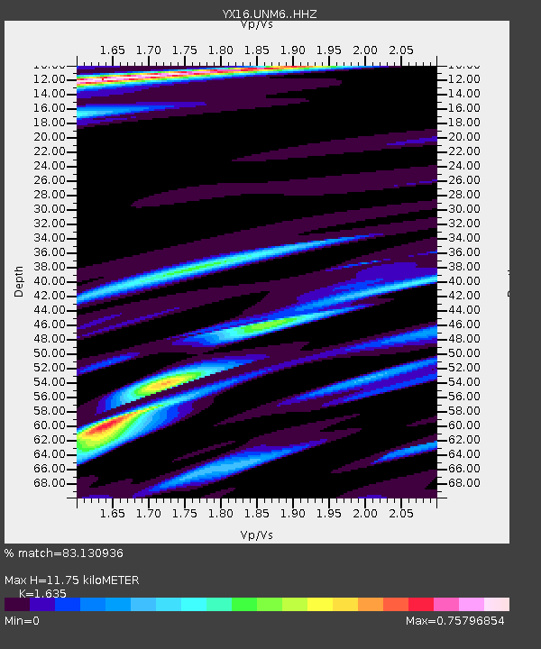
| Estimated Moho Depth: |
11.75 km |
| Estimated Crust Vp/Vs: |
1.63 |
| Assumed Crust Vp: |
6.316 km/s |
| Estimated Crust Vs: |
3.863 km/s |
| Estimated Crust Poisson's Ratio: |
0.20 |
|
| Radial Match: |
83.130936 % |
| Radial Bump: |
259 |
| Transverse Match: |
70.62585 % |
| Transverse Bump: |
311 |
| SOD ConfigId: |
34243671 |
| Insert Time: |
2024-05-02 15:10:31.945 +0000 |
| GWidth: |
2.5 |
| Max Bumps: |
400 |
| Tol: |
0.001 |
|

Signal To Noise
| Channel | StoN | STA | LTA |
| YX:UNM6: :HHZ:20230120T11:30:53.130005Z | 7.068275 | 2.5198967E-6 | 3.5650802E-7 |
| YX:UNM6: :HHN:20230120T11:30:53.130005Z | 1.4109489 | 3.2519176E-7 | 2.3047735E-7 |
| YX:UNM6: :HHE:20230120T11:30:53.130005Z | 3.740606 | 2.0670159E-6 | 5.525885E-7 |
| Arrivals |
| Ps | 1.3 SECOND |
| PpPs | 4.6 SECOND |
| PsPs/PpSs | 5.8 SECOND |


