You are here: Home > Network List > US - United States National Seismic Network Stations List
> Station EGMT Eagleton, Montana, USA > Earthquake Result Viewer
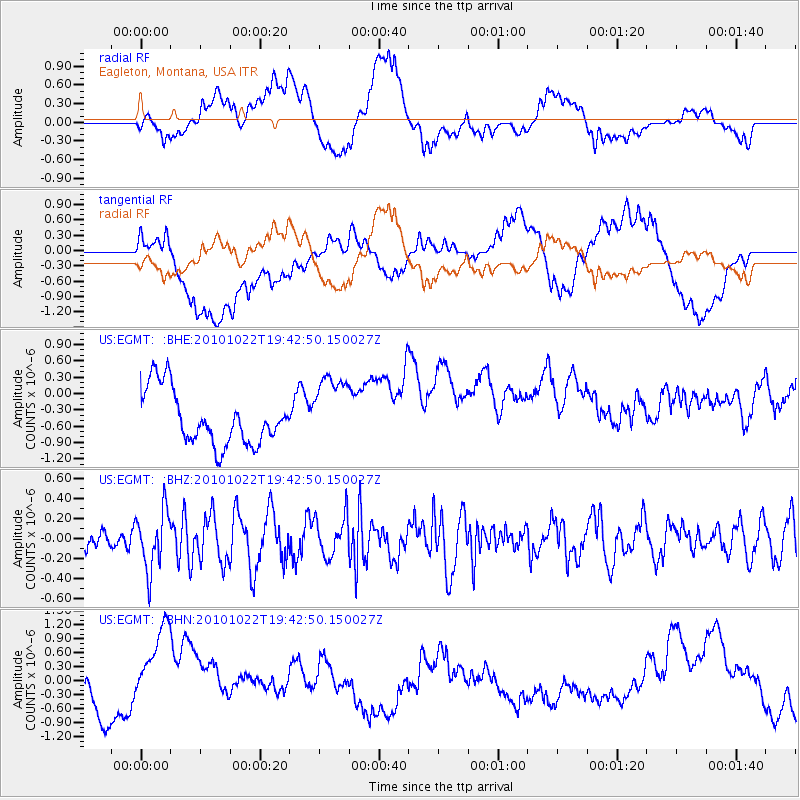
EGMT Eagleton, Montana, USA - Earthquake Result Viewer
*The percent match for this event was below the threshold and hence no stack was calculated.
| Earthquake location: |
Chile-Bolivia Border Region |
| Earthquake latitude/longitude: |
-20.9/-68.4 |
| Earthquake time(UTC): |
2010/10/22 (295) 19:31:37 GMT |
| Earthquake Depth: |
132 km |
| Earthquake Magnitude: |
5.8 MW, 5.4 MB, 5.8 MW |
| Earthquake Catalog/Contributor: |
WHDF/NEIC |
|
| Network: |
US United States National Seismic Network |
| Station: |
EGMT Eagleton, Montana, USA |
| Lat/Lon: |
48.02 N/109.75 W |
| Elevation: |
1055 m |
|
| Distance: |
78.0 deg |
| Az: |
333.015 deg |
| Baz: |
140.796 deg |
| Ray Param: |
$rayparam |
*The percent match for this event was below the threshold and hence was not used in the summary stack. |
|
| Radial Match: |
30.52581 % |
| Radial Bump: |
400 |
| Transverse Match: |
19.481672 % |
| Transverse Bump: |
400 |
| SOD ConfigId: |
339645 |
| Insert Time: |
2011-02-24 07:58:34.990 +0000 |
| GWidth: |
2.5 |
| Max Bumps: |
400 |
| Tol: |
0.001 |
|
Signal To Noise
| Channel | StoN | STA | LTA |
| US:EGMT: :BHZ:20101022T19:42:50.150027Z | 2.8603208 | 2.9442737E-7 | 1.0293509E-7 |
| US:EGMT: :BHN:20101022T19:42:50.150027Z | 3.8975632 | 1.1300975E-6 | 2.8994975E-7 |
| US:EGMT: :BHE:20101022T19:42:50.150027Z | 1.37834 | 6.7999713E-7 | 4.93345E-7 |
| Arrivals |
| Ps | |
| PpPs | |
| PsPs/PpSs | |


