You are here: Home > Network List > TA - USArray Transportable Network (new EarthScope stations) Stations List
> Station 121A Cookes Peak, Deming, NM, USA > Earthquake Result Viewer
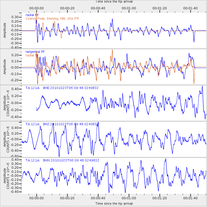
121A Cookes Peak, Deming, NM, USA - Earthquake Result Viewer
*The percent match for this event was below the threshold and hence no stack was calculated.
| Earthquake location: |
Near Coast Of Central Chile |
| Earthquake latitude/longitude: |
-37.7/-73.4 |
| Earthquake time(UTC): |
2010/10/23 (296) 05:58:27 GMT |
| Earthquake Depth: |
15 km |
| Earthquake Magnitude: |
5.7 MB, 5.1 MS, 5.5 MW, 5.5 MW |
| Earthquake Catalog/Contributor: |
WHDF/NEIC |
|
| Network: |
TA USArray Transportable Network (new EarthScope stations) |
| Station: |
121A Cookes Peak, Deming, NM, USA |
| Lat/Lon: |
32.53 N/107.79 W |
| Elevation: |
1652 m |
|
| Distance: |
76.9 deg |
| Az: |
330.645 deg |
| Baz: |
152.609 deg |
| Ray Param: |
$rayparam |
*The percent match for this event was below the threshold and hence was not used in the summary stack. |
|
| Radial Match: |
67.800026 % |
| Radial Bump: |
400 |
| Transverse Match: |
75.24866 % |
| Transverse Bump: |
400 |
| SOD ConfigId: |
339645 |
| Insert Time: |
2011-02-24 08:03:48.190 +0000 |
| GWidth: |
2.5 |
| Max Bumps: |
400 |
| Tol: |
0.001 |
|
Signal To Noise
| Channel | StoN | STA | LTA |
| TA:121A: :BHZ:20101023T06:09:48.024983Z | 2.488656 | 2.4308792E-7 | 9.767839E-8 |
| TA:121A: :BHN:20101023T06:09:48.024983Z | 0.9794074 | 9.3211085E-8 | 9.51709E-8 |
| TA:121A: :BHE:20101023T06:09:48.024983Z | 1.4944905 | 1.3922987E-7 | 9.316209E-8 |
| Arrivals |
| Ps | |
| PpPs | |
| PsPs/PpSs | |


