You are here: Home > Network List > TA - USArray Transportable Network (new EarthScope stations) Stations List
> Station 133A Hamilton Ranch, Breckenridge, TX, USA > Earthquake Result Viewer
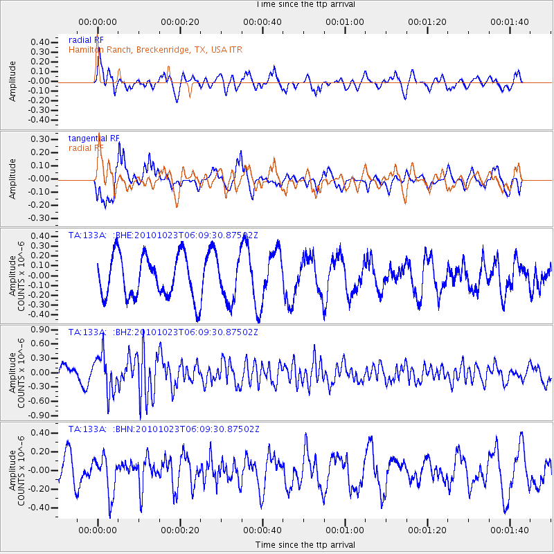
133A Hamilton Ranch, Breckenridge, TX, USA - Earthquake Result Viewer
*The percent match for this event was below the threshold and hence no stack was calculated.
| Earthquake location: |
Near Coast Of Central Chile |
| Earthquake latitude/longitude: |
-37.7/-73.4 |
| Earthquake time(UTC): |
2010/10/23 (296) 05:58:27 GMT |
| Earthquake Depth: |
15 km |
| Earthquake Magnitude: |
5.7 MB, 5.1 MS, 5.5 MW, 5.5 MW |
| Earthquake Catalog/Contributor: |
WHDF/NEIC |
|
| Network: |
TA USArray Transportable Network (new EarthScope stations) |
| Station: |
133A Hamilton Ranch, Breckenridge, TX, USA |
| Lat/Lon: |
32.61 N/98.92 W |
| Elevation: |
418 m |
|
| Distance: |
73.9 deg |
| Az: |
337.736 deg |
| Baz: |
159.154 deg |
| Ray Param: |
$rayparam |
*The percent match for this event was below the threshold and hence was not used in the summary stack. |
|
| Radial Match: |
68.93007 % |
| Radial Bump: |
400 |
| Transverse Match: |
81.45505 % |
| Transverse Bump: |
352 |
| SOD ConfigId: |
339645 |
| Insert Time: |
2011-02-24 08:10:28.575 +0000 |
| GWidth: |
2.5 |
| Max Bumps: |
400 |
| Tol: |
0.001 |
|
Signal To Noise
| Channel | StoN | STA | LTA |
| TA:133A: :BHZ:20101023T06:09:30.87502Z | 2.3686593 | 3.954193E-7 | 1.6693802E-7 |
| TA:133A: :BHN:20101023T06:09:30.87502Z | 1.4922112 | 2.0839934E-7 | 1.3965807E-7 |
| TA:133A: :BHE:20101023T06:09:30.87502Z | 1.0110048 | 2.1489974E-7 | 2.1256055E-7 |
| Arrivals |
| Ps | |
| PpPs | |
| PsPs/PpSs | |


