You are here: Home > Network List > TA - USArray Transportable Network (new EarthScope stations) Stations List
> Station O33A Hebron, NE, USA > Earthquake Result Viewer
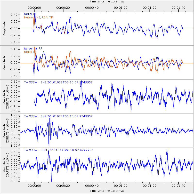
O33A Hebron, NE, USA - Earthquake Result Viewer
*The percent match for this event was below the threshold and hence no stack was calculated.
| Earthquake location: |
Near Coast Of Central Chile |
| Earthquake latitude/longitude: |
-37.7/-73.4 |
| Earthquake time(UTC): |
2010/10/23 (296) 05:58:27 GMT |
| Earthquake Depth: |
15 km |
| Earthquake Magnitude: |
5.7 MB, 5.1 MS, 5.5 MW, 5.5 MW |
| Earthquake Catalog/Contributor: |
WHDF/NEIC |
|
| Network: |
TA USArray Transportable Network (new EarthScope stations) |
| Station: |
O33A Hebron, NE, USA |
| Lat/Lon: |
40.08 N/97.58 W |
| Elevation: |
480 m |
|
| Distance: |
80.6 deg |
| Az: |
341.39 deg |
| Baz: |
160.749 deg |
| Ray Param: |
$rayparam |
*The percent match for this event was below the threshold and hence was not used in the summary stack. |
|
| Radial Match: |
64.51071 % |
| Radial Bump: |
400 |
| Transverse Match: |
59.352676 % |
| Transverse Bump: |
400 |
| SOD ConfigId: |
339645 |
| Insert Time: |
2011-02-24 08:12:25.990 +0000 |
| GWidth: |
2.5 |
| Max Bumps: |
400 |
| Tol: |
0.001 |
|
Signal To Noise
| Channel | StoN | STA | LTA |
| TA:O33A: :BHZ:20101023T06:10:07.974995Z | 2.2727501 | 3.083998E-7 | 1.3569455E-7 |
| TA:O33A: :BHN:20101023T06:10:07.974995Z | 2.2729824 | 2.2362127E-7 | 9.8382316E-8 |
| TA:O33A: :BHE:20101023T06:10:07.974995Z | 1.6407055 | 2.8053697E-7 | 1.7098557E-7 |
| Arrivals |
| Ps | |
| PpPs | |
| PsPs/PpSs | |


