You are here: Home > Network List > TA - USArray Transportable Network (new EarthScope stations) Stations List
> Station E31A Nome, ND, USA > Earthquake Result Viewer
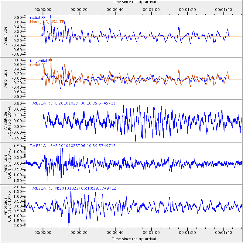
E31A Nome, ND, USA - Earthquake Result Viewer
*The percent match for this event was below the threshold and hence no stack was calculated.
| Earthquake location: |
Near Coast Of Central Chile |
| Earthquake latitude/longitude: |
-37.7/-73.4 |
| Earthquake time(UTC): |
2010/10/23 (296) 05:58:27 GMT |
| Earthquake Depth: |
15 km |
| Earthquake Magnitude: |
5.7 MB, 5.1 MS, 5.5 MW, 5.5 MW |
| Earthquake Catalog/Contributor: |
WHDF/NEIC |
|
| Network: |
TA USArray Transportable Network (new EarthScope stations) |
| Station: |
E31A Nome, ND, USA |
| Lat/Lon: |
46.56 N/97.89 W |
| Elevation: |
427 m |
|
| Distance: |
86.8 deg |
| Az: |
343.328 deg |
| Baz: |
160.755 deg |
| Ray Param: |
$rayparam |
*The percent match for this event was below the threshold and hence was not used in the summary stack. |
|
| Radial Match: |
72.40963 % |
| Radial Bump: |
400 |
| Transverse Match: |
61.261017 % |
| Transverse Bump: |
400 |
| SOD ConfigId: |
339645 |
| Insert Time: |
2011-02-24 08:14:23.520 +0000 |
| GWidth: |
2.5 |
| Max Bumps: |
400 |
| Tol: |
0.001 |
|
Signal To Noise
| Channel | StoN | STA | LTA |
| TA:E31A: :BHZ:20101023T06:10:39.574971Z | 3.1172388 | 4.773489E-7 | 1.5313198E-7 |
| TA:E31A: :BHN:20101023T06:10:39.574971Z | 1.0424528 | 2.5648623E-7 | 2.4604108E-7 |
| TA:E31A: :BHE:20101023T06:10:39.574971Z | 1.2252444 | 2.5793744E-7 | 2.1051918E-7 |
| Arrivals |
| Ps | |
| PpPs | |
| PsPs/PpSs | |


