You are here: Home > Network List > TA - USArray Transportable Network (new EarthScope stations) Stations List
> Station G32A Webster, SD, USA > Earthquake Result Viewer
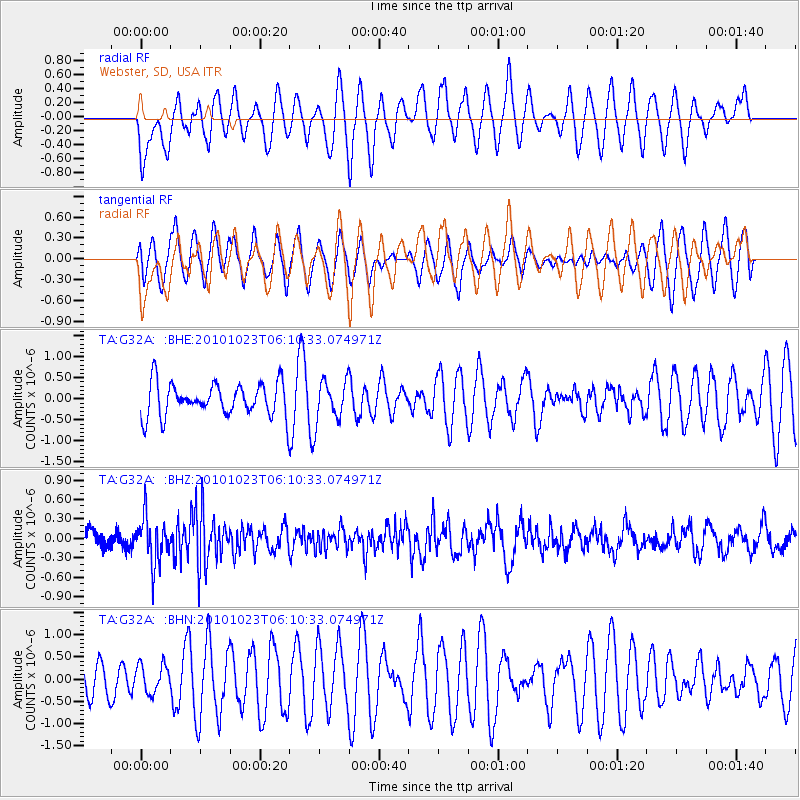
G32A Webster, SD, USA - Earthquake Result Viewer
*The percent match for this event was below the threshold and hence no stack was calculated.
| Earthquake location: |
Near Coast Of Central Chile |
| Earthquake latitude/longitude: |
-37.7/-73.4 |
| Earthquake time(UTC): |
2010/10/23 (296) 05:58:27 GMT |
| Earthquake Depth: |
15 km |
| Earthquake Magnitude: |
5.7 MB, 5.1 MS, 5.5 MW, 5.5 MW |
| Earthquake Catalog/Contributor: |
WHDF/NEIC |
|
| Network: |
TA USArray Transportable Network (new EarthScope stations) |
| Station: |
G32A Webster, SD, USA |
| Lat/Lon: |
45.26 N/97.50 W |
| Elevation: |
566 m |
|
| Distance: |
85.4 deg |
| Az: |
343.157 deg |
| Baz: |
161.022 deg |
| Ray Param: |
$rayparam |
*The percent match for this event was below the threshold and hence was not used in the summary stack. |
|
| Radial Match: |
41.73158 % |
| Radial Bump: |
400 |
| Transverse Match: |
56.361332 % |
| Transverse Bump: |
400 |
| SOD ConfigId: |
339645 |
| Insert Time: |
2011-02-24 08:15:10.131 +0000 |
| GWidth: |
2.5 |
| Max Bumps: |
400 |
| Tol: |
0.001 |
|
Signal To Noise
| Channel | StoN | STA | LTA |
| TA:G32A: :BHZ:20101023T06:10:33.074971Z | 1.9518331 | 3.5579916E-7 | 1.8228974E-7 |
| TA:G32A: :BHN:20101023T06:10:33.074971Z | 0.8221825 | 3.2208465E-7 | 3.9174353E-7 |
| TA:G32A: :BHE:20101023T06:10:33.074971Z | 1.265091 | 4.9885045E-7 | 3.9431984E-7 |
| Arrivals |
| Ps | |
| PpPs | |
| PsPs/PpSs | |


