You are here: Home > Network List > US - United States National Seismic Network Stations List
> Station EGMT Eagleton, Montana, USA > Earthquake Result Viewer
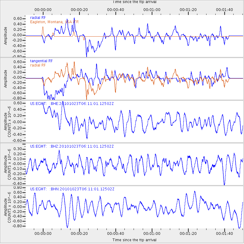
EGMT Eagleton, Montana, USA - Earthquake Result Viewer
*The percent match for this event was below the threshold and hence no stack was calculated.
| Earthquake location: |
Near Coast Of Central Chile |
| Earthquake latitude/longitude: |
-37.7/-73.4 |
| Earthquake time(UTC): |
2010/10/23 (296) 05:58:27 GMT |
| Earthquake Depth: |
15 km |
| Earthquake Magnitude: |
5.7 MB, 5.1 MS, 5.5 MW, 5.5 MW |
| Earthquake Catalog/Contributor: |
WHDF/NEIC |
|
| Network: |
US United States National Seismic Network |
| Station: |
EGMT Eagleton, Montana, USA |
| Lat/Lon: |
48.02 N/109.75 W |
| Elevation: |
1055 m |
|
| Distance: |
91.3 deg |
| Az: |
336.522 deg |
| Baz: |
151.935 deg |
| Ray Param: |
$rayparam |
*The percent match for this event was below the threshold and hence was not used in the summary stack. |
|
| Radial Match: |
45.375614 % |
| Radial Bump: |
400 |
| Transverse Match: |
39.29214 % |
| Transverse Bump: |
400 |
| SOD ConfigId: |
339645 |
| Insert Time: |
2011-02-24 08:17:06.741 +0000 |
| GWidth: |
2.5 |
| Max Bumps: |
400 |
| Tol: |
0.001 |
|
Signal To Noise
| Channel | StoN | STA | LTA |
| US:EGMT: :BHZ:20101023T06:11:01.12502Z | 0.58807886 | 9.860103E-8 | 1.6766634E-7 |
| US:EGMT: :BHN:20101023T06:11:01.12502Z | 0.6669817 | 1.5711643E-7 | 2.3556332E-7 |
| US:EGMT: :BHE:20101023T06:11:01.12502Z | 0.87295043 | 2.3513611E-7 | 2.693579E-7 |
| Arrivals |
| Ps | |
| PpPs | |
| PsPs/PpSs | |


