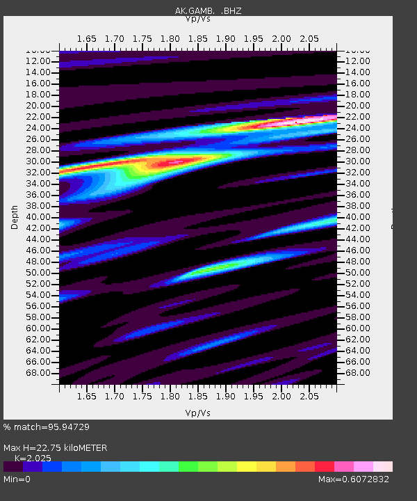
GAMB Gambell Broadband - Earthquake Result Viewer
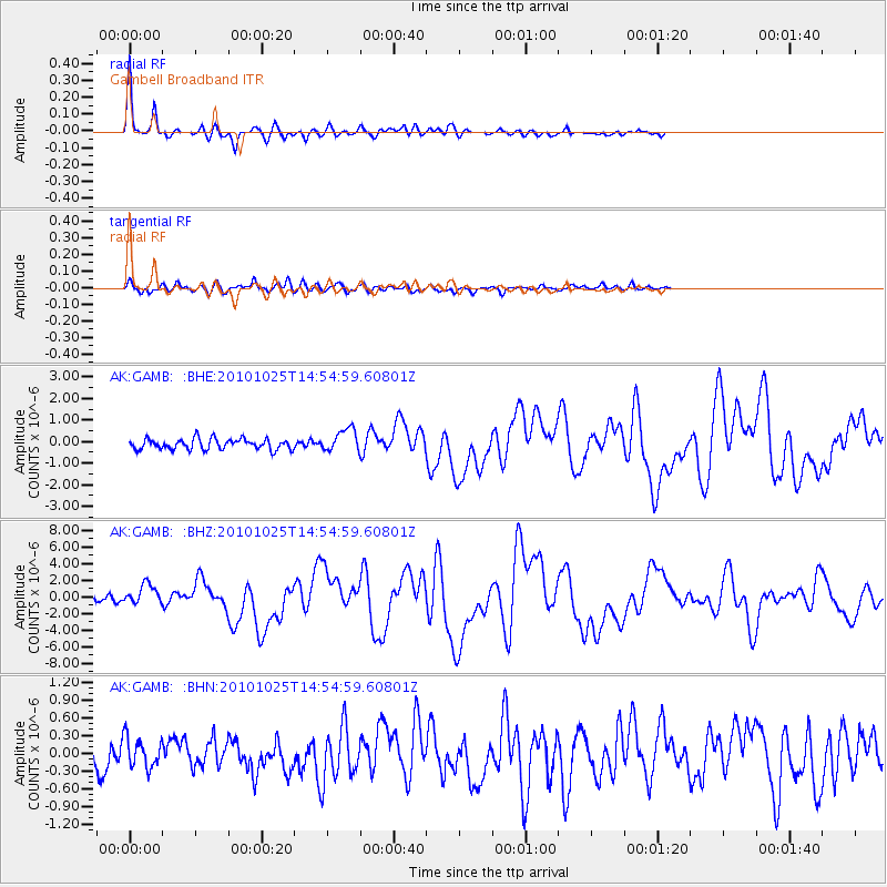
Earthquake location: Southern Sumatra, Indonesia
Earthquake latitude/longitude: -3.5/100.1
Earthquake time(UTC): 2010/10/25 (298) 14:42:22 GMT
Earthquake Depth: 20 km
Earthquake Magnitude: 6.5 MB, 7.3 MS, 7.8 MW, 7.7 MW
Earthquake Catalog/Contributor: WHDF/NEIC
Network: AK Alaska Regional Network
Station: GAMB Gambell Broadband
Lat/Lon: 63.78 N/171.70 W
Elevation: 10 m
Distance: 92.3 deg
Az: 26.386 deg
Baz: 266.864 deg
Ray Param: 0.04147392
Estimated Moho Depth: 22.75 km
Estimated Crust Vp/Vs: 2.03
Assumed Crust Vp: 6.24 km/s
Estimated Crust Vs: 3.081 km/s
Estimated Crust Poisson's Ratio: 0.34
Radial Match: 95.94729 %
Radial Bump: 272
Transverse Match: 80.43525 %
Transverse Bump: 400
SOD ConfigId: 339645
Insert Time: 2011-02-24 08:23:44.111 +0000
GWidth: 2.5
Max Bumps: 400
Tol: 0.001

Signal To Noise

ChannelStoNSTALTA
AK:GAMB: :BHZ:20101025T14:54:59.60801Z3.69430331.2054586E-63.26302E-7
AK:GAMB: :BHN:20101025T14:54:59.60801Z0.930355852.5313184E-72.7208065E-7
AK:GAMB: :BHE:20101025T14:54:59.60801Z2.17015655.3489566E-72.4647795E-7
Arrivals
Ps3.8 SECOND
PpPs11 SECOND
PsPs/PpSs15 SECOND